
Collared wolves in Colorado traveled farther west into Moffat County and close to the Wyoming state line.
00:2201:37
- NEXT UP IN 5What should the Bruins do with Jake DeBrusk? Atlantic Division Rankings & Golden Knights preview
- A Deep Dive into a Pivotal March for the Minnesota Wild
Author: Jennifer Campbell-Hicks
Published: 12:51 PM MST February 28, 2024
Updated: 12:56 PM MST February 28, 2024
DENVER — Grey wolves reintroduced to Colorado last year expanded their travel in the state in the second month of tracking by wildlife officials, according to a map released Wednesday.
Ten gray wolves were released in Grand and Summit counties in mid-December in accordance with a voter-approved reintroduction program. Those were in addition to two wolves that dispersed into Jackson County on their own and produced six pups in 2021. In February 2023, Colorado Parks and Wildlife (CPW) officials placed collars on two of those wolves in North Park.
> The video above aired Feb. 8: Study: It will be decades until Colorado sees environmental impact from wolf reintroduction
A map released by CPW last month showed where the wolves roamed between Dec. 18 and Jan. 22, using GPS data collected from all 12 collared wolves, which are the only known wolves currently in the state.
A new map released Wednesday showed the wolves’ travel over the second month of tracking, between Jan. 23 and Feb. 27.
Two wolves traveled from Western Routt County into eastern Moffat County over the past month, CPW said in a news release. The map also shows activity in more watersheds in northern Jackson and Larimer counties, close to the Wyoming state line. The CPW map doesn’t differentiate between the activity of the wolves released in December and the ones that were already here.
RELATED: Here’s where Colorado wolves have roamed since their introduction

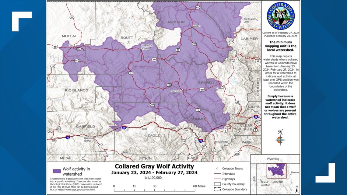
Credit: Colorado Parks and Wildlife
> Move the slider to see the changes between the first two CPW wolf activity maps:
The maps show wolf activity in watersheds. Just because an area shows wolf activity doesn’t mean that wolves are present through the entire watershed or are currently there, CPW said.
CPW said the collars record a position every four hours. After four locations are recorded, that data is transmitted via satellite to biologists. CPW staff can use the data to see where wolves have been but not where they are at any current point in time, the agency said.
The map will be updated on the fourth Wednesday of every month, CPW said.
RELATED: Wolves move into Moffat County, tracking data shows
RELATED: Two Colorado wolves wandering close to Wyoming border, where killing them is legal
