
- Andrew Freedman, author ofAxios Generate
- https://www.axios.com/2024/02/01/dangerous-atmospheric-river-southern-california
Share on facebook (opens in new window)
Share on twitter (opens in new window)
Share on linkedin (opens in new window)
Share on email (opens in new window)
Californians are being urged to prepare for the strongest atmospheric river event of the season, which may deliver historic amounts of rain to SoCal.
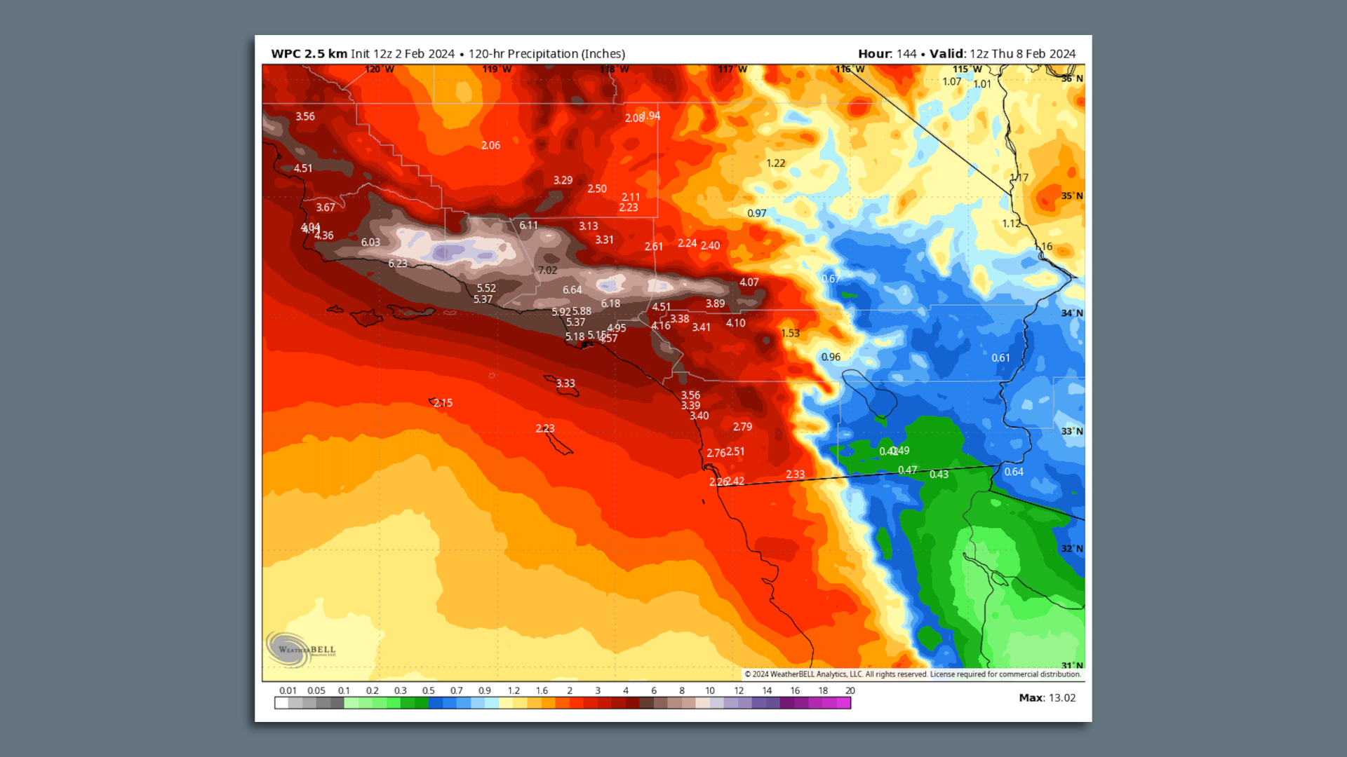
Threat level: The National Weather Service warned early Friday that confidence is growing in “significant to extreme rainfall” from this storm across Southern California in particular.
- The storm will bring a swath of 4-to-8-inch-plus rainfall totals, with locally heavier amounts, from Monterrey southward to San Diego.
- Downtown Los Angeles could see as much as 5 to 8 inches of rain in just 3 days based on current forecasts, with the potential for higher amounts. Downtown LA’s average annual rainfall is about 14 inches.
- Several feet of snow are likely to fall in the mountains of Southern California, perhaps enough to block access to some communities.
What they’re saying: The National Weather Service forecast office in Los Angeles is calling the storm “very dangerous” and noting that flash flooding and river flooding will occur quickly on Sunday given that the ground is already saturated from recent rains.
- “Everyone, especially those near or in south-facing mountains, needs to start preparing now for possible evacuations during or even before the storm hits,” the NWS LA said in an online forecast discussion Thursday evening ET.
- “Significant threat of widespread and very dangerous flash flooding Sunday into Monday especially from southern Santa Barbara County southward,” the NWS stated early Friday morning.
State of play: The NWS said Thursday there is a 30-50% chance that some mountain areas could receive up to 15 inches of rain, and coastal and valley regions even see 6 to 10 inches of rain out of this storm, including LA.
- Those odds may have decreased slightly on Friday.
Zoom in: The east-to-west oriented mountains in Southern California, known as the Transverse Ranges that are found in Santa Barbara, Ventura and Los Angeles counties, among others, could pick up a foot of rain as a firehose of tropical moisture is directed at them from the southwest.
- Landslides, rockslides and flooding are a growing concern. These impacts have claimed lives in past atmospheric river events in this region.
- This storm may also have higher winds than other atmospheric rivers so far this winter, since there will be a rapidly intensifying area of low pressure moving close to the Central California coastline.
Context: The storm will tap into a strong atmospheric river, which is a narrow highway of moisture at mid-levels of the atmosphere, and aim it at the California coast for a prolonged period.
- This air will contain a tremendous amount of water vapor, which will be enhanced by unusually high sea surface temperatures.
- Human-caused climate change is making extreme precipitation events more common and intense across the U.S. and worldwide and is predicted to make atmospheric rivers even wetter in coming years.
- Similar ingredients led to record and damaging deluges in Ventura, California in December, and San Diego last month.
Of note: 13.5 million people, including areas of LA County, are under a “moderate risk” for excessive rainfall Monday. The NWS is warning of significant urban, river and stream flooding, along with landslide dangers.
- It is rare to have a moderate risk outlook, the second highest on the scale, issued several days in advance for a large U.S. city, and is indicative both of the potential for damaging flooding as well as the level of forecast confidence.
- “This storm could end up generating unprecedented amounts of rain across a widespread area!” NWS forecasters in LA wrote Thursday about a high-end rainfall scenario.
The bottom line: Californians won’t get much of a break between storms, but the NWS says preparations for the late weekend event need to get under way.
Editor’s note: This article has been updated with new forecast details.
