The number of wild camels in Australia has increased in recent years.
(CNN)About 10,000 camels are at risk of being shot and killed in a drought-ravaged region of Australia, after complaints that the thirsty animals are endangering locals as they desperately search for water.
Aboriginal officials in the remote northwest of South Australia approved the cull, which is due to begin on Wednesday and is expected to last for five days.
The area’s local government, Anangu Pitjantjatjara Yankunytjatjara (APY), said in a memo posted on Facebook that “extremely large groups of camels and other feral animals in and around communities” are “putting pressure on the remote Aboriginal communities” as they search for water.
“With the current ongoing dry conditions the large camel congregations threatening the APY communities and infrastructure, camel control is needed,” the note added.
The cull will see professional shooters kill thousands of the creatures, with CNN affiliate Seven News reporting that 10,000 are at risk.
Like most of the country, South Australia has been sweltering under extremely high temperatures for weeks.
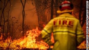
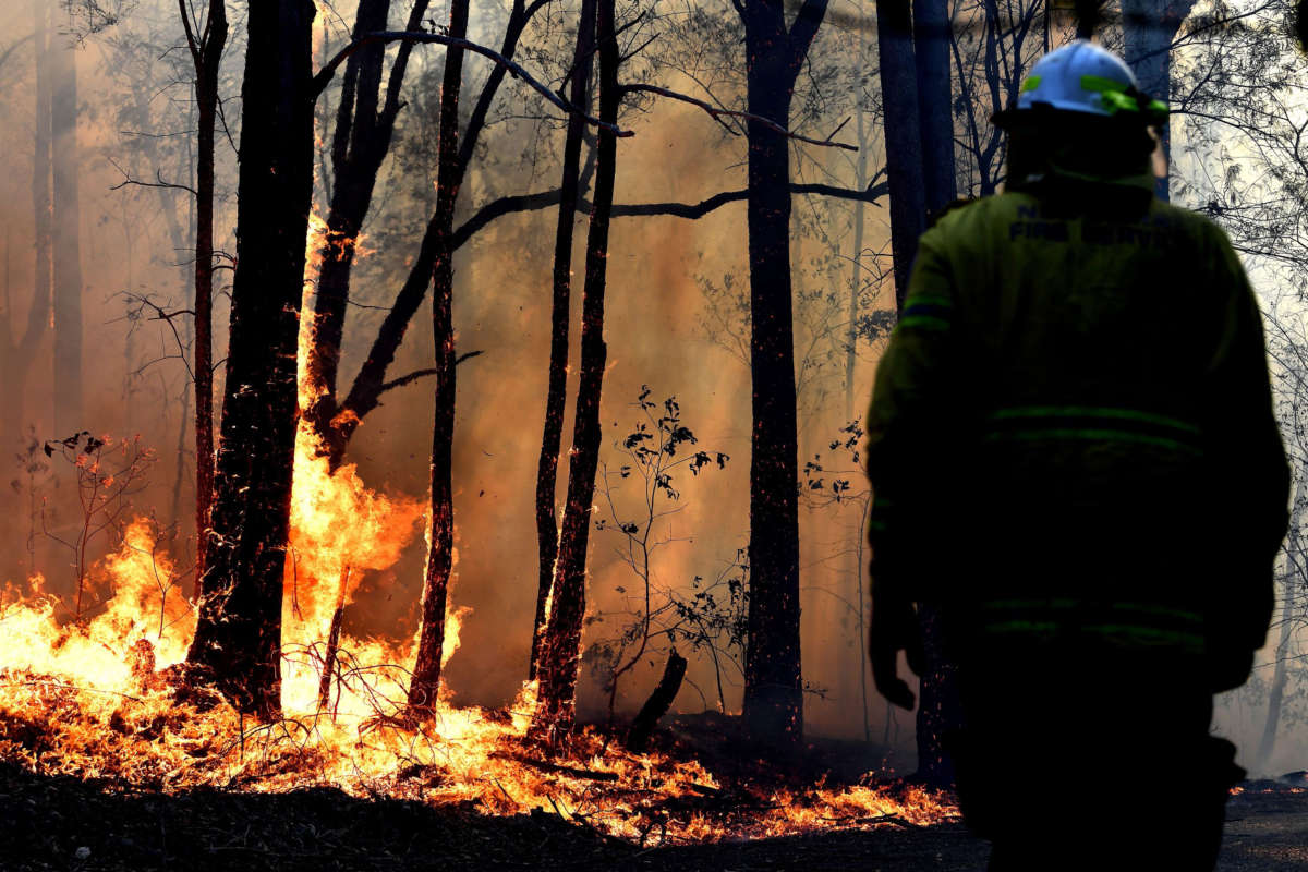
Though not as badly hit as neighboring New South Wales, the state has suffered from the bushfires tearing through the country, blanketing cities in smoke and decimating native wildlife populations.
Marita Baker, an APY board member, told The Australian newspaper that her community had been inundated by the creatures as they hunt for water.
“We have been stuck in stinking hot and uncomfortable conditions, feeling unwell, because the camels are coming in and knocking down fences, getting in around the houses and trying to get to water through air conditioners,” she told the newspaper.
The APY region is in an extremely remote area of South Australia and is sparsely populated. Only about 2,300 people live in the region, which is roughly the size of the US state of Kentucky.
There are believed to be more than 1 million camels in Australia and the country’s camel population is growing rapidly.
In another grim, viral video posted on Twitter, a man drives into the fire-ravaged town of Batlow in New South Wales, filming both sides of the road littered with the charred remains of animals.
It is estimated that hundreds of millions of animals have been killed by the blazes.
Fires are nothing new in Australia, but they have been growing more intense and becoming more destructive in recent years, a problem that has been exacerbated by climate change. And animals have been on the front lines as Australia has the highest rate of species loss of any area in the world, and researchers fear that rate could increase as the fire disaster continues
Small spot fires still burn on January 05, 2020 between Orbost and Cann River along the Princes Highway, Australia. (Photo by Darrian Traynor/Getty Images)
NEW SOUTH WALES, Australia — The New South Wales Police Force has taken legal action against more than 180 people for bushfire-related offenses since late last year. That number includes 24 people who deliberately lit bushfires.
Nationwide, at least 25 people have been killed and 2,000 homes destroyed by the blazes, which have so far scorched an area twice the size of the U.S. state of Maryland, the Associated Press reports.
Wildfires are common during the southern hemisphere summer, and Australians generally take a pragmatic view of them. But this year’s fires arrived unusually early, fed by drought and the country’s hottest and driest year on record.
Rain and cooler temperatures on Monday were bringing some relief to communities battling the fires. But the rain was also making it challenging for fire crews to complete strategic burns as they tried to prepare for higher temperatures that have been forecast for later in the week.
In this aerial view ice lies in a lake formed by meltwater from the Rhone glacier on August 19, 2019 near Obergoms, Switzerland. Credit: Sean Gallup Getty Images
The 2010s were almost certainly the hottest decade on record — and it showed. The world burned, melted and flooded. Heat waves smashed temperature records around the globe. Glaciers lost ice at accelerating rates. Sea levels continued to swell.
At the same time, scientists have diligently worked to untangle the chaos of a rapidly warming planet.
In the past decade, scientists substantially improved their ability to draw connections between climate change and extreme weather events. They made breakthroughs in their understanding of ice sheets. They raised critical questions about the implications of Arctic warming. They honed their predictions about future climate change.
As another decade begins, scientists say there are more questions to be answered. We asked climate researchers across a variety of disciplines about the biggest priorities and hottest topics for the 2020s. Here’s what they said.
ARCTIC MYSTERIES
The Arctic is warming faster than anywhere else on Earth, with temperatures rising at least twice as fast as the global average. Many scientists believe that understanding the consequences of Arctic warming is essential for making accurate predictions about climate change around the world.
Some of these links are straightforward. Melting Arctic ice pouring into the ocean can raise global sea levels. Thawing permafrost can release large amounts of carbon dioxide and methane into the atmosphere, potentially accelerating the rate of global warming.
Others are more contentious.
In the last decade, a growing scientific debate has arisen about the influence of Arctic warming on global climate and weather patterns, particularly in the midlatitudes.
Some observational studies have pointed to a statistical connection between Arctic warming and weather events in places like the United States, Europe and parts of Asia — for instance, a link between shrinking sea ice and cold winters in Siberia, or Arctic heat waves and extreme winter weather in the United States.
The trouble is models have a hard time capturing the causes driving these connections.
“No one argues that the Arctic meltdown will affect weather patterns, the question is exactly how,” said Arctic climate expert Jennifer Francis, a researcher at Woods Hole Research Center. “So figuring out what’s not right in the models will be a major focus. Without realistic models, it’s hard to use them to separate Arctic influences from other possible factors.”
Resolving the debate will require “a combination of data and modeling,” according to NASA climatologist Claire Parkinson. Many scientists are already hard at work on this issue.
One ongoing project known as the Polar Amplification Model Intercomparison Project is conducting a series of coordinated model experiments, all using the same standard methods, to investigate the Arctic climate and its connections to the rest of the globe. Experts say these kinds of projects may help explain why modeling studies conducted by different groups with different methods don’t always get the same results.
At the same time, improving the way that physical processes are represented in Arctic climate models is also essential, according to Xiangdong Zhang, an Arctic and atmospheric scientist at the University of Alaska, Fairbanks.
Outside that debate, there are still big questions about the Arctic climate to resolve. Scientists know the Arctic is heating up at breakneck speed — but they’re still investigating all the reasons why.
Researchers believe a combination of feedback processes are probably at play. Sea ice and snow help reflect sunlight away from the Earth. As they melt away, they allow more heat to reach the surface, warming the local climate and causing even more melting to occur.
One key question for the coming decade, Zhang said in an email, is “what relative role each of the physical processes plays and how these processes work together” to drive the accelerating warming.
Unraveling these feedbacks will help scientists better predict how fast the Arctic will warm in the future, according to Francis — and how quickly they should expect its consequences to occur. They include vanishing sea ice, thawing permafrost and melting on the Greenland ice sheet.
OCEANS AND ICE
Sea-level rise is one of the most serious consequences of climate change, with the potential to displace millions of people in coastal areas around the world.
At the moment, the world’s oceans are rising at an average rate of about 3 millimeters each year. It appears to be speeding up over time. That may not sound like much, but scientists are already documenting an increase in coastal flooding in many places around the world.
Accurately predicting the pace of future sea-level rise is one of the biggest priorities in climate science. And one of the biggest uncertainties about future sea-level rise is the behavior of the Greenland and Antarctic ice sheets, both of which are pouring billions of tons of ice into the ocean each year.
Recent satellite studies have found that ice loss in both places is speeding up. Antarctica is losing about three times as much ice as it was in the 1990s, while losses in Greenland may be as much as seven times higher than they were in previous decades.
Investigating the processes driving the accelerations — and then using that knowledge to fine-tune predictions of future sea-level rise — is a key priority for 2020 and beyond, according to Marco Tedesco, an ice sheet expert at Columbia University.
“How do we connect the physical processes that we do understand are creating this acceleration from Greenland and Antarctica, very likely over the next decade, to sea-level rise impacts?” he asked E&E News. “And how do we account for the potential shocks of the things that we cannot anticipate still?”
Some scientists worry that as ice loss continues to speed up in both Greenland and Antarctica, parts of the ice sheets could eventually destabilize and collapse entirely — leading to catastrophic sea-level rise.
In recent years, scientists have discovered that warm ocean currents are helping to melt some glaciers from the bottom up, both in Greenland and particularly in parts of West Antarctica. Better understanding the relationship between oceans and ice is a key priority for glacier experts, Tedesco said.
At the same time, monitoring the way water melts and moves along the top of the ice is also a major priority. In Greenland, climate-driven changes in the behavior of large air currents like the jet stream may be helping to drive more surface melting.
“The important thing is to understand how Greenland mass loss can be connected to the recent changes in the atmospheric circulation that we are witnessing,” Tedesco said.
EXTREME WEATHER EVENTS
The past decade saw leaps and bounds in a field of climate research known as “attribution science” — the connection between climate change and extreme weather events.
It was once thought to be impossible, but scientists are now able to estimate the influence of global warming on individual events, like heat waves or hurricanes. In the past few years alone, scientists have found that some events are now occurring that would have been impossible in a world with no human-caused climate change.
As attribution science has advanced, researchers have been able to tackle increasingly complex events, like hurricanes and wildfires, which were previously too complicated to evaluate with any confidence. They’ve gotten faster, too — researchers are now able to assess some extreme events nearly in real time.
Some organizations are working to develop sophisticated attribution services, similar to weather services, which would release analyses of extreme events as soon as they occur. The German national weather service; the United Kingdom’s Met Office; and the Copernicus program, part of the European Centre for Medium-Range Weather Forecasts, have all begun exploring these kinds of projects.
At the same time, scientists are working to improve their predictions of future extreme events in a warming world.
So far, climate models predict that many extreme weather events will happen more frequently, or will become more severe, as the climate continues to change. Heat waves will be hotter, hurricanes will intensify, heavy rainfall events may happen more frequently in some places, and droughts may be longer in others.
Continuing to improve these kinds of predictions — and then communicating them in useful ways to communities that will be affected by them — is a major priority, according to Piers Forster, director of the Priestley International Centre for Climate at the University of Leeds.
There’s often great uncertainty when it comes to predicting extreme weather events, he noted — different climate models sometimes deliver vastly different results. But it can often be both expensive and time-consuming to run the models enough times, and at high enough resolutions, to investigate and narrow these uncertainties.
Tackling this issue is one of the key challenges for climate modeling in the coming years, Forster said, noting that “we need to get clever about how we use models to make projections and how we test them.”
PROJECTING THE FUTURE
Predicting how much the Earth will warm, given a certain level of greenhouse gas emissions, may seem like the simplest goal of climate modeling. But it’s harder than it sounds.
Climate models don’t always agree on the Earth’s exact sensitivity to greenhouse gas emissions — although they do tend to fall within a certain range. If global carbon dioxide concentrations were to double, for instance, models from the past decade have tended to predict that the Earth would warm from between 1.5 and 4.5 degrees Celsius.
Scientists around the world are working on a new suite of updated climate models, which will be used to inform future reports produced by the Intergovernmental Panel on Climate Change. But there’s one issue that’s already raising eyebrows, according to Zeke Hausfather, a climate scientist at the University of California, Berkeley — so far, the newer models seem to be predicting a much higher climate sensitivity than the older models.
“The high end is much higher,” he told E&E News. “There’s a number of models above 4.8 degrees sensitivity and even up to 5.6.”
Only about 20 new models have submitted results; far more will come pouring in before the project is complete. And as Hausfather pointed out, other recent studies have suggested that the Earth’s climate sensitivity might actually be narrower than the old models suggested.
But it’s something to keep in mind at a time when accurate predictions about future warming are more pressing than ever.
“The fact that some of these models are high is interesting but doesn’t necessarily mean we should believe them over other lines of evidence,” Hausfather said. “It just reflects the fact that climate sensitivity is this huge remaining source of uncertainty in our climate projections.”
At the same time, climate modelers are also working to hone their projections in other ways. Models are able to capture increasingly complex processes the more they advance. But there are still a few key areas scientists are focused on improving.
Clouds, for instance, are believed to have a significant influence on the climate system. But they’re notoriously difficult to reproduce in climate models. Certain aspects of the carbon cycle are also underrepresented in models, Hausfather noted — for instance, the way that forests and oceans absorb or release greenhouse gases into the atmosphere.
And scientists are also working to develop more realistic climate scenarios for their modeling projects. In the past, many studies have focused on a “business as usual” climate scenario, which suggests high rates of future greenhouse gas emissions, the continued expansion of coal, and other assumptions about industry and socioeconomics that may no longer be realistic, according to Hausfather.
While global climate action is still significantly lagging when it comes to meeting the goals of the Paris climate agreement, the future may not be as dire as previous business-as-usual climate studies would suggest. Focusing new studies on more realistic scenarios may be more useful to policymakers and communities trying to plan for the future.
“In many ways the range of possible futures is narrowing,” Hausfather said. “As we get closer to 2100 and as the world takes more climate action, the worst-case 4 degrees-plus warming scenarios are a lot less likely.”
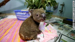
Ecologists at the University of Sydney are estimating that nearly half a billion animals have been killed in Australia’s unprecedented and catastrophic wildfires, which have sparked a continent-wide crisis and forced tens of thousands of people to flee their homes in desperation.
News Corp Australiareported Wednesday that “there are real concerns entire species of plants and animals have been wiped out by bushfires following revelations almost 500 million animals have died since the crisis began.”
ADVERTISING
“Ecologists from the University of Sydney now estimate 480 million mammals, birds, and reptiles have been lost since September,” according to News Corp. “That figure is likely to soar following the devastating fires which have ripped through Victoria and the [New South Wales] South Coast over the past couple of days, leaving several people dead or unaccounted for, razing scores of homes and leaving thousands stranded.”
The horrifying figures come as images and videos of animals suffering severe burns and dehydration continue to circulate on social media.
Mark Graham, an ecologist with the National Conservation Council, told the Australian parliament that “the fires have burned so hot and so fast that there has been significant mortality of animals in the trees, but there is such a big area now that is still on fire and still burning that we will probably never find the bodies.”
00:0000:38
Koalas in particular have been devastated by the fires, Graham noted, because they “really have no capacity to move fast enough to get away.”
As Reutersreported Tuesday, “Australia’s bushland is home to a range of indigenous fauna, including kangaroos, koalas, wallabies, possums, wombats, and echidnas. Officials fear that 30 percent of just one koala colony on the country’s northeast coast, or between 4,500 and 8,400, have been lost in the recent fires.”
Australia’s coal-touting Prime Minister Scott Morrison has faced growing scrutiny for refusing to take sufficient action to confront the wildfires and the climate crisis that is driving them. Since September, the fires have burned over 10 million acres of land, destroyed more than a thousand homes, and killed at least 17 people—including 9 since Christmas Day.
On Thursday, the government of New South Wales (NSW) declared a state of emergency set to take effect Friday morning as the wildfires are expected to intensify over the weekend.
“We’ve got a lot of fire in the landscape that we will not contain,” said Rob Rogers, deputy commissioner of the NSW Rural Fire Service. “We need to make sure that people are not in the path of these fires.”
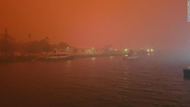
(CNN)Skies turned blood red above parts of southeast Australia on Sunday as residents sought refuge from deadly bushfires, and a senior firefighter described the previous 24 hours as “one of our worst days ever.”
Photographs of Pambula, in the state of New South Wales, showed an eerie, smoke-filled landscape, with deserted streets illuminated by an otherworldly, blazing red sky.
About 30 kilometers (19 miles) south, blood-red skies loomed over the town of Eden. There, hundreds of residents were seeking shelter on the beach on police advice, one Eden resident told CNN. Many houses have been destroyed in the area, and officials said they feared there would be fatalities.
A total of 146 fires are burning across the state, with 65 uncontained, according to the NSW Rural Fire Service (NSWRFS). About 2,700 firefighters were tackling the blazes on Sunday.
“Conditions have eased today and firefighters have gained the upper hand on several dangerous fires. There are no total fire bans in place for Monday,” the NSWRFS posted on Twitter.
A blood-red sky looms over Eden, New South Wales, on January 5, 2020.
Earlier, NSWRFS Commissioner Shane Fitzsimmons told a news conference that Saturday was “one of our worst days ever on record.”
A “considerable number” of properties were lost across NSW on Saturday, Fitzsimmons said, adding that a 47-year-old man had died from cardiac arrest while fighting a fire threatening his friend’s home in Batlow. The man is the 24th person to die nationwide this fire season.
Separately, four firefighters in NSW were hospitalized due to smoke inhalation, heat exhaustion and hand burns. They have since been released.
Fitzsimmons said that conditions could worsen again in the coming days. “Today will be a relief — psychological relief but not what we need,” he said.
Fire-induced thunderstorms over New South Wales, seen from a flight on January 5, 2020.
Australia’s flag carrier Qantas canceled all flights to and from the country’s capital, Canberra, on Sunday due to smoke and hazardous weather conditions.
An airline passenger spotted huge clouds caused by the fires over NSW during a flight from Sydney to Melbourne on Sunday. They are pyrocumulonimbus clouds — fire-induced thunderstorms — which form when hot air rises from a ground based fire, according to CNN meteorologists. The air cools and condenses as it ascends, causing a cloud to form.
“This process is similar to the development of a thunderstorm,” said CNN Weather’s Derek Van Dam. “As such, a downdraft forms within the base of the pyrocumulonimbus cloud, allowing for embers to be picked up and carried to form new fires.”
Photos:In photos: Bushfires rage through Australia
The flight deck of a C-130J Hercules is lit by the red glow of the fires below as the aircrew attempts to land in Merimbula to drop off fire and rescue crews to assist fighting the bushfires on Sunday, January 5.
Hide Caption
1 of 74
In the neighboring state of Victoria, three fires have combined to form a single blaze bigger than the New York borough of Manhattan. The fires joined overnight Friday in the Omeo region, creating a 6,000-hectare (23 square mile) blaze, according to Gippsland’s Department of Environment, Land, Water and Planning.
The country’s capital, Canberra, smashed its heat record of 80 years, reaching 44 degrees Celsius (111 degrees Fahrenheit) on Saturday afternoon, according to the country’s Bureau of Meteorology. In the western Sydney suburb of Penrith, the mercury climbed to 48.9 degrees Celsius (120 degrees Fahrenheit) — setting a new record for the whole Sydney basin.
Victoria has declared a state of disaster, and NSW has declared a state of emergency — both granting extraordinary powers and additional government resources to battle the fires.
It marked the first time Victoria has activated these powers since the 2009 Black Saturday fires, the deadliest bushfire disaster on record in Australia with 173 people killed and 500 injured.
Speaking at a news conference Sunday, Australian Prime Minister Scott Morrison said it was another difficult night across the country — in particular in NSW, Victoria and South Australia.
Morrison — who in December faced criticism for taking a vacation to Hawaii during the fires — said the government’s response was the most significant and comprehensive ever to a natural disaster.
An eerie, smoke-filled landscape in Pambula, New South Wales, on January 5, 2020.
“I believe that’s where we need to focus our attention, and we are seeking to communicate that directly to Australians to ensure they have comfort that the response is matching the need,” he said.
“Sure there’s been a lot of commentary, there’s been plenty of criticism. I’ve had the benefit of a lot of analysis on a lot of issues. But I can’t be distracted by that, and the public, I know, are not distracted by that.
“What they need us to focus on, all of us actually, all of us focusing on the needs there and getting the support where it needs to go. That’s very much where my focus is, and that’s where it will continue to be.”
In a news release on Sunday, the Australia Defence Force (ADF) said it was significantly increasing its support in fighting the massive fires and had called up 3,000 army reserve forces and others with specialist capabilities.
An Australian army soldier helps people evacuate onto a Black Hawk helicopter in Omeo, Victoria on January 5, 2020.
They will also provide aircraft, ships and its largest vessel, HMAS Adelaide, with helicopter landing capabilities.
One priority for the ADF will be to assist in evacuations of people in isolated communities. HMAS Adelaide, the Australian Navy’s largest ship, arrived off the coast of Eden on Sunday as evacuations took place there.
Some ADF bases will be opened to house those displaced by the fires. Troops will also help move material and supplies, support recovery centers, and aid in fire trail clearance.
New Zealand and Singapore have also offered military support, and the ADF is assessing where they can help, the news release said.
Members of the UK royal family sent their “thoughts and prayers” to Australians affected by the massive bushfires through social media accounts on Saturday. Queen Elizabeth and Prince Philip issued a message of condolence expressing thanks to emergency services. “I have been deeply saddened to hear of the continued bushfires and their devastating impact across many parts of Australia,” the Queen wrote in a statement published on Twitter.
On their Instagram account, the Duke and Duchess of Cambridge said they were “shocked and deeply saddened” by “the fires that are destroying homes, livelihoods and wildlife across much of Australia,” posting a photo of a kangaroo with a burning building in the background.
Meanwhile, the Duke and Duchess of Sussex urged support for those affected by the environmental crisis in an Instagram post linking to a number of Australian fundraisers, such as the Australian Red Cross, the Country Fire Authority and the New South Wales Rural Fire Service.
When the Greenland ice sheet went into a record meltdown in the summer of 2019, it raised a very terrifying specter of the future. Here was a 12.5-billion-ton mass of ice—one that’s been melting at a quickening pace since the 1980s—melting in a way scientists didn’t expect to happen for decades.
While the ice sheet won’t completely disappear for centuries, any further increase in its melt will put coastal communities at risk of inundation. There’s an argument to be made that we should do everything possible to save the ice, and a new study explores a very controversial idea to that end: cooling the planet.
The findings, published last month in Earth’s Future, explore what would happen if the world pumped particles high into the atmosphere that would reflect sunlight back into space. This high-altitude air conditioning scheme, known as solar radiation management or SRM, would bring down the global average temperature. The paper’s results show that cooling would help slow—though not stop—the melting of the ice sheet. That could buy coastal regions time but also change the climate in other ways that may end up hurting other regions around the world.
The threats to Greenland ice are coming from seemingly all directions. Relatively hot water has undercut the glaciers tumbling down from the ice sheet, while rising air temperatures have melted it from above. Recent wildfires have also left a cake of dark soot that absorbs more sunlight, enhancing surface melt. And then there are surface pools of water that funnel into cracks in the ice, further destabilizing it. In short, climate change is engaged in an all-out war on the ice sheet that will only intensify in the coming century. Projections indicate the ice sheet melting could lead to anywhere from 10 to 20 centimeters (4 to 8 inches) of sea level rise this century, with much higher rates of rise in the Pacific.
To understand the impact geoengineering could have on Greenland, scientists ran models that simulate the climate throughout the century under a few different scenarios. In some scenarios, greenhouse gas pollution increased throughout the century or peaked by mid-century. They then took those same scenarios and added in a splash of geoengineering. The models they ran basically shot particles into the stratosphere around the equator that then dispersed around the globe. The impacts are based in part on what happens after volcanic eruptions, and the study used the equivalent a quarter of a Pinatubo eruption every year.
The results show that the planet-cooling properties of the particles would extend to Greenland, lowering air temperatures there by about 1.1 degrees Celsius (2 degrees Fahrenheit) compared to the scenarios without geoengineering. Runoff from melt would drop anywhere from 20 to 32 percent, with the biggest difference coming under the high greenhouse gas emissions scenario. All that means sea level rise would slow.
Doug MacMartin, a Cornell scientist who has studied geoengineering, told Earther the study’s findings were in line with you’d expect from solar radiation management but that the findings used older models. Future work updated with new models could go a long way to building on the findings, and the study itself notes that some key aspects of atmospheric circulation are simplified.
But it’s not all puppies and unicorns. Geoengineering alone wouldn’t be able to stop ice from melting. It could also wreak havoc with weather in other parts of the globe, potentially pitting nations against each other. And then there’s the most concerning aspect of geoengineering, which is that once we start in on cooling the planet, stopping it could risk sudden, catastrophic climate change. So any plan to do this requires a long, hard think and making sure everyone has a say, not just rich countries with tons of coastal real estate.
“Could geoengineering affect the Arctic? How effective would it be at offsetting projected polar changes due to climate change? Would there be any side effects or unintended consequences?” Ben Kravitz, a geoengineering researcher at Indiana University, told Earther in an email. “Answering these questions is critical, and this study is a welcome step in addressing such questions.”
Indeed, as the world continues to put off the best climate change solution (which would be cutting emissions), it moves closer to considering more risky ways to address the changes set in motion by decades of unbridled fossil fuel use. That makes exploring these ideas in the scientific literature terrifying and important all at once.
“We don’t know enough about [solar radiation management] today, but we don’t want to be in a position of making hasty choices some point in the future—which is exactly why studies like this one are so important,” MacMartin told Earther in an email.
Equally important, and something that MacMartin emphasized as well, is actually doing the hard work of cutting carbon emissions. As the results make clear, blocking out sunlight is nowhere near enough to protect the coasts.
SHARE THIS STORY
GET OUR NEWSLETTER
Subscribe
MORE FROM EARTHER
Turns Out a Wild Geoengineering Plan to Refreeze Arctic Sea Ice Isn’t the Best Idea
What Would It Be Like to Live in an Era of Geoengineering?
Ecologists at the University of Sydney are estimating that nearly half a billion animals have been killed in Australia’s unprecedented and catastrophic wildfires, which have sparked a continent-wide crisis and forced tens of thousands of people to flee their homes in desperation.
News Corp Australiareported Wednesday that “there are real concerns entire species of plants and animals have been wiped out by bushfires following revelations almost 500 million animals have died since the crisis began.”
“Ecologists from the University of Sydney now estimate 480 million mammals, birds, and reptiles have been lost since September,” according to News Corp. “That figure is likely to soar following the devastating fires which have ripped through Victoria and the [New South Wales] South Coast over the past couple of days, leaving several people dead or unaccounted for, razing scores of homes and leaving thousands stranded.”
Mark Graham, an ecologist with the National Conservation Council, told the Australian parliament that “the fires have burned so hot and so fast that there has been significant mortality of animals in the trees, but there is such a big area now that is still on fire and still burning that we will probably never find the bodies.”
Koalas in particular have been devastated by the fires, Graham noted, because they “really have no capacity to move fast enough to get away.”
As Reutersreported Tuesday, “Australia’s bushland is home to a range of indigenous fauna, including kangaroos, koalas, wallabies, possums, wombats, and echidnas. Officials fear that 30 percent of just one koala colony on the country’s northeast coast, or between 4,500 and 8,400, have been lost in the recent fires.”
Fears entire species of plants and animals lost to bushfires
There are real concerns entire species of plants and animals have been wiped out by bushfires following revelations almost 500 million animals have died since the crisis began.
Australia’s coal-touting Prime Minister Scott Morrison has faced growing scrutiny for refusing to take sufficient action to confront the wildfires and the climate crisis that is driving them. Since September, the fires have burned over 10 million acres of land, destroyed more than a thousand homes, and killed at least 17 people — including 9 since Christmas Day.
On Thursday, the government of New South Wales (NSW) declared a state of emergency set to take effect Friday morning as the wildfires are expected to intensify over the weekend.
“We’ve got a lot of fire in the landscape that we will not contain,” said Rob Rogers, deputy commissioner of the NSW Rural Fire Service. “We need to make sure that people are not in the path of these fires.”
Most of the time, the ground beneath our feet feels permanent. Landscapes, oceans, mountain ranges — all seem enduring compared to the human lifespan. But the Earth can change quickly and dramatically at times. The past year saw some of those moments, from wildfires that rewrote ecosystems to earthquakes that rearranged topography in an instant. Here are some of 2019’s most enduring changes on Earth.
The Amazon burns
(Image credit: Bruno Rocha/Fotoarena/Newscom)
The 2019 fire season in the Amazon basin saw mind-boggling infernos tear through the largest rainforest on the planet. According to the Brazilian Institute for Space Research (INPE), the rate of fires in Brazil and the Amazon was 80% higher in 2019 than in the year before. Smoke from the fires in Augustturned SãoPaulo day into an ashy night. The fires were set by humans in attempts to clear underbrush and make way for agriculture, but drought conditions led to many of these blazes spreading out of control.
The burn scars joined with human logging to accelerate the loss of the Amazon rainforest. According to INPE, deforestation in Brazilspiked by 278% in July 2019, a loss of 870 square miles (2,253 square kilometers) of vegetation in that month alone.
Arctic sea ice thinned
(Image credit: NASA)
In the continuation of another sobering trend, 2019 saw Arctic sea ice continue to dwindle. Increasingly, ice-free seas are the future in the high latitudes, according to Arctic ice models. This year, this new normal asserted itself in the Bering Sea, whichbecame almost ice-free by April. In the past, sea ice hit its maximum in April and persisted until the melt started around May.
(Image credit: NETTY DHARMA SOMBA/AFP via Getty Images)
In March, relentless rains turned steep hillsides in Indonesia’s Papua region into rivers of mud and debris. More than 100 people were killed and almost as many went missing when landslides tore through villages. Flash floods drove thousands of residents from their homes, according to the Red Cross and Red Crescent Societies. The rain fell over steep slopes in the region’s Cyclops Mountains, many of which have been deforested for agriculture; the resulting flooding and landslides left deep scars on the slopes and contaminated reservoirs used for drinking water.
Peru rocked by earthquake
(Image credit: GUADALUPE PARDO/AFP via Getty Images)
At 2:41 a.m. local time on May 26, a magnitude-8.0 earthquake struck near the small town of Yurimaguas, Peru. The death toll was limited to one, thanks to the quake’s remote location and deep origin point in the Earth’s crust. But the quake also released the energy equivalent of 6,270,000 tons of TNT, permanently altering the landscape. Banks crumbed on the Huallaga River, landslides tore through hillside vegetation and roads cracked.
A volcano rumbled to life
Advertisement
(Image credit: NASA Earth Observatory)
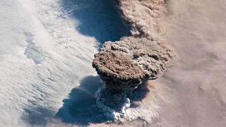
The Raikoke volcano, a remote mountain on the archipelago of volcanic peaks between Russia’s Kamchatka peninsula and Japan’s Hokkaido Island, had been quiet since 1924 — until this year. On June 22, Raikoke blew its top, sending a mushroom-shaped cloud of ash 43,000 feet (13 kilometers) into the atmosphere.
The remoteness of the eruption meant that it seriously affected only air travel, forcing planes to divert to avoid the ash cloud. But an employee on a cruise ship that came close to the island the day after the eruption was able to photograph the sudden change in the once-sleepy volcano. The slopes of the mountain were covered with inches of thick, light ash, and flows of ash and debris many feet thick had traveled down the volcano’s flanks, according to the Smithsonian Institution’s Global Volcanism Program. The island’s vegetation was smothered in the ash.
PROMOTED BY TEDDYFEED
SPONSORED
T
READ MORE
T
[Gallery] This Wedding Dress Made Guests Truly Uncomfortable
TEDDYFEED.COM
Earthquake Island vanished
Advertisement
(Image credit: Newscom)
As quickly as it arrived in 2013, Pakistan’s “Earthquake Island” disappeared in 2019.
Earthquake Island was produced during a 7.7-magnitude earthquake that killed more than 800 people in southwestern Pakistan in September 2013. As the Arabian tectonic plate and the Eurasian plate ground together, buried mud shot toward the surface, carrying rocks and boulders with it. The resulting island protruded 65 feet (20 m) above the ocean surface, and measured 295 feet (90 m) wide and 130 feet (40 m) long.
This year, erosion wiped away all but a few sediment traces of Earthquake Island. NASA researchers say that this short life span is common for islands produced by “mud volcanoes,” the term for deep mud and rock being ejected through fissures in the crust.
Dorian devastated the Bahamas
(Image credit: NOAA)
On Sept. 1, 2019, Hurricane Dorian rolled over the Bahamas as a slow-moving Category 5 storm, subjecting the Abacos Islands and Grand Bahama Island to hours of heavy rains and winds topping out at 185 miles per hour (295 km/h). On Sept. 3, as the storm moved away, 60% of Grand Bahama Island was underwater, according to satellite imagery captured by the Finnish firm ICEYE SAR Satellite Constellation.
The hurricane devastated the human infrastructure on the islands and killed dozens of people. The storm also damaged much of the Bahama’s natural ecosystem, tearing up trees and threatening wildlife that relies on the islands’ ecology. Scientists worry that the disturbance may have killed the last Bahama nuthatches (Sitta pusilla insulari) in the world. These small birds, which are found only on Grand Bahama, were down to just a few individuals after Hurricane Matthew hit the island in 2016. It’s unconfirmed if any of the birds made it through Hurricane Dorian, but the monster storm and saltwater flooding hit the birds’ forest habitat hard, leading to fears that Dorian was the nail in the coffin for this rare and endangered species.
As the Atlantic reeled from Dorian, the Pacific experienced a marine heatwave of unusual significance. The event in the Pacific was a near-repeat of “The Blob,” a huge expanse of unusually warm water that persisted off the U.S. west coast from 2013 to 2016. According to the California Current Marine Heatwave Tracker, the 2019 version of the blob was nearly as large and warm as the previous event, which affected salmon and other marine life. Sea-surface temperatures in the blob were 5.4 degrees Fahrenheit (3 degrees Celsius) hotter than average.
These heat waves are, by definition, transitory events, not permanent increases in sea temperature. But scientists are increasingly worried that these heat events will become the new normal. “We learned with ‘the Blob’ and similar events worldwide that what used to be unexpected is becoming more common,” Cisco Werner, director of scientific programs at the National Oceanic and Atmospheric Administration, said in a NOAA news piece released in September.
Antarctica lost a tooth
Advertisement
(Image credit: ESA Sentinel-1A)
Better late than never? An iceberg that scientists expected to crack off Antarctica by 2015 finally made its move in September.
The chunk of ice 632 square miles (1,636 square kilometers) in size rifted from the icy continent on Sept. 26;.it broke off the Amery Ice Shelf in East Antarctica. That ice formation seems to calve large ‘bergs every 60 to 70 years, scientists reported.
Despite the change in Antarctica’s coastline, the iceberg was already floating, so its calving did not affect sea levels. However, ice loss in Antarctica is accelerating — scientists estimate that the continent has lost 3 trillion tons in the last 25 years, translating to 0.3 inches (8 millimeters) of sea-level rise.
The atmosphere got more carbon-rich
(Image credit: Shutterstock)
Advertisement
Perhaps the most far-reaching change to the planet in 2019 was the continued pumping of carbon into the oceans and atmosphere, which hit a record high this year.
According to a report by the Global Carbon Project, human activity — from agriculture to transportation to industry — emitted approximately 43.1 billion tons of carbon in 2019. That makes 2019 a record-setter, breaking the previous high set in 2018. Excess carbon in the atmosphere remains there for decades to centuries, so the emissions released in 2019 will reverberate far into the future. According to the Intergovernmental Panel on Climate Change (IPCC), without a rapid reduction of greenhouse gas emissions, the atmosphere is expected to warm 5.4 F (3 C) above pre-industrial levels by 2100.
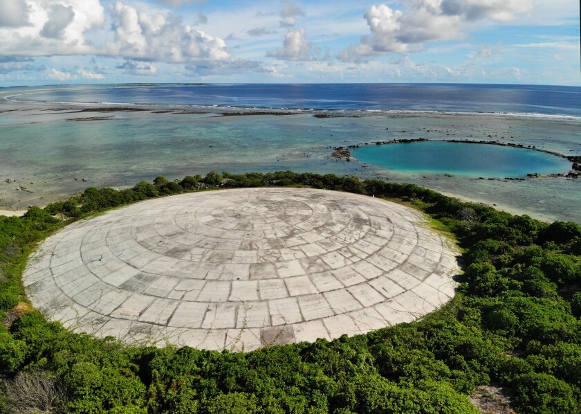
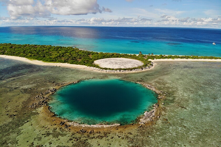
Congress is demanding that the Department of Energy investigate an aging, cracking U.S. nuclear waste dump threatened by climate change and rising seas in the Marshall Islands.
As part of the new National Defense Authorization Act, signed last week by President Trump, the energy agency must submit a report by mid-June on the risks that Runit Dome poses to the people, environment and wildlife of Enewetak lagoon — the site of 44 nuclear bomb detonations during the Cold War.
It must also include an assessment of how climate change could affect the site, although the term “climate change” was dropped as the bill moved through the Senate Armed Services Committee, which is chaired by Oklahoma’s James M. Inhofe, one of Congress’ most outspoken climate change skeptics.
According to the law, the energy agency must submit a report that includes an “assessment of how rising sea levels might affect the dome.”
The investigation was applauded by at least one representative of the Marshall Islands, which continues to contend with the radioactive legacy of U.S. nuclear testing. The island nation sits in a remote part of the central Pacific, 5,000 miles southwest of Los Angeles.
“We are encouraged by the inclusion in the [act] of the requirement,” said Rhea Moss-Christian, chairwoman of the Marshall Islands’ National Nuclear Commission, a three-person government panel that reports directly to the president on nuclear issues in the islands.
She said the original language for the bill, which was introduced by U.S. Rep. Tulsi Gabbard (D-Hawaii), required a plan for relocating the waste, as well as an assessment of how local food is affected by the dome.
Moss-Christian said her committee was disappointed these elements were not included in the final version, which the president signed. But she added that she was hopeful the new law “will yield useful results to better inform our decision making.”
There was no immediate response from the Lawrence Livermore National Laboratory, which the Energy Department has assigned to monitor Runit Dome and the radiation leaking from it.
The waste site, known alternatively as the Tomb, or simply the Dome, holds more than 3.1 million cubic feet — or 35 Olympic-size swimming pools — of U.S.-produced radioactive soil and debris, including lethal amounts of plutonium.
Nowhere else has the United States saddled another country with so much of its nuclear waste, a product of its Cold War atomic testing program.
From 1946 to 1958, the United States detonated 67 nuclear bombs on, in and above the Marshall Islands — vaporizing whole islands, carving craters into its shallow lagoons and exiling hundreds of people from their homes.
Department of Energy contractors admitted last spring that the dome is vulnerable to rising sea levels and storm waves, and is leaking into Enewetak lagoon. Studies have shown elevated levels of radioactive contamination in local seafood, including giant clams.
This year, the Los Angeles Times published an investigation of the dome and Enewetak lagoon, revealing that it was the location of at least a dozen biological weapons tests and also the repository for 130 tons of soil from an irradiated Nevada testing site.
The investigation also documented decades of U.S. deception in the Marshall Islands, including the withholding of critical information about people’s exposure to radiation. Thousands of documents about the testing program are still classified, leaving many Marshallese distrustful and unsure about the full impact of U.S. weapons testing there.
For decades, the Marshallese have expressed alarm about Runit Dome and its potential risk to the 650 inhabitants of Enewetak lagoon, who fish and harvest seafood from the lagoon, and collect coconut, pandanus, coconut crabs and breadfruit from islands in the atoll.
In July, a team led by Emlyn Hughes of Columbia University’s K=1 Project — a program designed to investigate nuclear weapons issues across the globe — found elevated levels of radiation on Runit Island.
According to their research, levels were higher than those found emanating from soils near the sites of the Chernobyl meltdown and the Fukushima disaster.
“At last the U.S. government seems to be getting serious about addressing this serious environmental issue that it created decades ago,” said Michael Gerrard, a legal scholar at Columbia University’s law school. “This is a very welcome development.”
It also comes soon after the U.S. announced its intention to extend its Compact of Free Association with the Marshall Islands, which was set to expire in 2023.
The compact, which was initially signed in 1986, provides the Marshallese government with funding, allows its citizens to work and travel in the United States without visas, and provides the U.S. government with a strategic military base on Kwajalein Atoll — the center for U.S. intercontinental ballistic missile testing.
Recently, the United States and another world power have been vying for influence over the Marshall Islands, because of its strategic position in the Pacific.
As China has increased its financial and military presence in the region, the United States has been losing footing with formerly staunch allies, including Kiribati and the Solomon Islands.
Many Marshallese argue the U.S. has not done enough to address its history of radioactive contamination in the islands or help the nation deal with the growing assaults of climate change.
A recent general election in the Marshall Islands could determine whether the government develops a closer relationship with China, which has been courting the island nation. The results are still not official, but New Zealand media reported that an opposition slate of candidates is ahead and could triumph over incumbent President Hilda Heine, resulting in policies more favorable to China.
Greta Thunberg tweeted: ‘Indigenous people are literally being murdered for trying to protect the forrest [sic] from illegal deforestation. Over and over again.’ Photograph: Pablo Blázquez Domínguez/Getty Images
Brazil’s far-right president Jair Bolsonaro has derided Greta Thunberg after the teenage climate activist added her voice to growing international condemnation of a surge of anti-indigenous violence in the Amazon.
“Indigenous people are literally being murdered for trying to protect the forrest [sic] from illegal deforestation. Over and over again,” Thunberg tweeted on Sunday alongside a video showing the aftermath of a drive-by shooting targeting indigenous leaders that left two dead.
“It is shameful that the world remains silent about this,” the 16-year-old campaigner added.
Bolsonaro – who activists accuse of green-lighting a new era of destruction and violence with his hardline anti-environment rhetoric – hit back on Tuesday.
“Greta’s been saying Indians have died because they were defending the Amazon,” a smirking Bolsonaro told reporters outside the presidential palace in Brazil’s capital, Brasília.
“It’s amazing how much space the press gives this kind of pirralha,” Bolsonaro added, using a Portuguese word that loosely translates as “little brat” or “pest”.
Bolsonaro had initially failed to remember Thunberg’s name, labelling her simply “that girl”.
Thunberg appeared to take Bolsonaro’s disparagement as a badge of honour, changing her Twitter biography to “Pirralha”.
Thunberg is far from alone in challenging Bolsonaro over the spike in rainforest destruction and attacks on indigenous communities during his first year in power.
Brazil’s Indigenous Missionary Council rights group reported in September that 153 indigenous territories had been invaded since the start of 2019 – more than twice last year’s figure of 76 – and said Bolsonaro’s “aggressive” talk was partly responsible.
After Saturday’s killings in the northern state of Maranhão, Brazil’s former environment minister, Marina Silva, tweeted: “This Amazon bloodbath demands a strong and swift response from Brazilian authorities.”
“We have been cut adrift and left unprotected by the Brazilian state,” wrote Sônia Guajajara, a prominent indigenous leader.
In a recent interview, the Amazon senator Randolfe Rodrigues said Brazil’s native peoples stood at a historic juncture as Bolsonaro pushed ahead with plans to open their lands to commercial mining.
“Not since the [1964-85] dictatorship have Brazil’s indigenous peoples felt as threatened as they do now,” Rodrigues said.


![Greta Thunberg tweeted: ‘Indigenous people are literally being murdered for trying to protect the forrest [sic] from illegal deforestation. Over and over again,’ alongside video of aftermath of drive-by shooting.](https://i.guim.co.uk/img/media/ad1d5ea19ac3e9c617376b4bdf0c4a3b100b02da/0_10_4000_2400/master/4000.jpg?width=300&quality=85&auto=format&fit=max&s=d8771abb729f9403e70be7c103ed8434)
