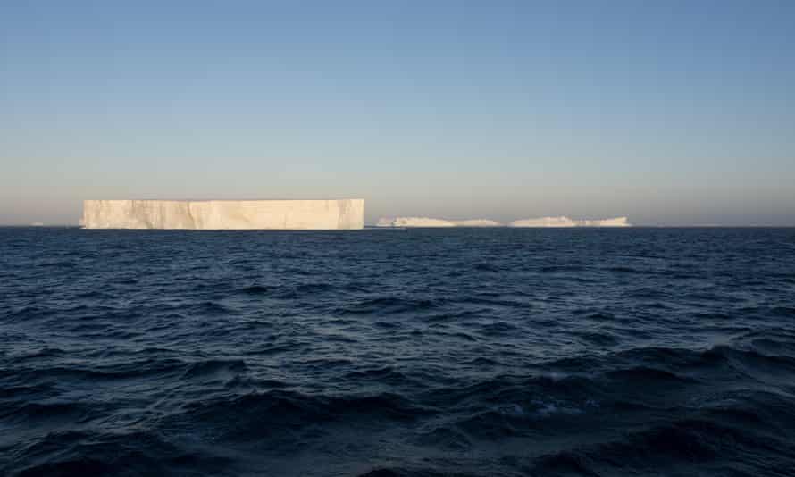
Organization says the Southern Ocean consists of the waters surrounding Antarctica, out to 60-degrees south latitude
Scientists have long known that the waters surrounding Antarctica form a ‘distinct ecological region defined, by ocean currents and temperatures’. Photograph: British Antarctic Survey/Reuters
Anyone who thought the world had four oceans will now have to think again, after the National Geographic Society announced it would recognize a new Southern Ocean in Antarctica, bringing the global total to five.
The National Geographic, a non-profit scientific and educational organization whose mapping standards are referenced by many atlases and cartographers, said the Southern Ocean consists of the waters surrounding Antarctica, out to 60-degrees south latitude.
National Geographic Society geographer Alex Tait said scientists have long known that the waters surrounding Antarctica form a “distinct ecological region defined, by ocean currents and temperatures”.
Tait told the Washington Post that the span of water is yet to be officially recognized as an ocean by the relevant international body: “But we thought it was important at this point to officially recognize it.”Advertisement
“People look to us for geographic fact: How many continents, how many countries, how many oceans? Up until now, we’ve said four oceans,” Tait said, referring to the Arctic, Atlantic, Indian and Pacific.
The US Board of Geographic Names, a federal body created in 1890 to establish and maintain “uniform geographic name usage” through the federal government, already recognizes the Southern ocean as occupying the same territory, but this is the first time the National Geographic has done so.
Attempts to ratify the boundaries and name of the Southern Ocean internationally have been thwarted.
The concept was proposed to the International Hydrographic Organization, which works to ensure the world’s seas, oceans and navigable waters are surveyed and charted, in 2000, but some of the IHO’s 94 members dissented. Despite that, Tait said it was important that the National Geographic christen the water area.
“We think it’s really important from an educational standpoint, as well as from a map-labeling standpoint, to bring attention to the Southern Ocean as a fifth ocean,” Tait told the Post.
“So when students learn about parts of the ocean world, they learn it’s an interconnected ocean, and they learn there’s these regions called oceans that are really important, and there’s a distinct one in the icy waters around Antarctica.”
I came face to face with the Doomsday Glacier (a.k.a. Thwaites glacier) in 2019, on a trip to Antarctica aboard the Nathaniel B. Palmer, a 308-foot-long icebreaker operated by the National Science Foundation. I had dubbed the Florida-sized slab of ice its nickname in an article I’d written a few years earlier, and the name stuck. Nevertheless, I was unprepared for how spooky it would be to actually confront the 100-foot-tall wall of ice from the deck of a ship. Locked up here was enough water to raise global sea levels nearly 10 feet. As I wrote in a dispatch from Antarctica on the day we encountered Thwaites, it was both terrifying and thrilling to know that our future is written in this craggy, luminous continent of ice.
Our world is heating up fast. And as every kid knows, on hot days, ice melts. The question is how quickly. At Thwaites, the melting is mostly a result of warm ocean water attacking it from below, which is stressing and fracturing both the ice shelf that protects the glacier and the glacier itself. Just how fast Thwaites and the other big glaciers that make up the West Antarctic ice sheet will all fall apart is one of the most important scientific questions of our time. And it is a question upon which the future of virtually every coastal city in the world depends. “We know there are tipping points in Antarctic ice sheets, and we also know that Antarctica is the biggest wildcard in the future sea level rise projections,” says Andrea Dutton, a professor of geology at the University of Wisconsin-Madison and a 2019 MacArthur Fellow. “Basically, it all comes down to ‘when will we reach that tipping point?’ ”
Last week, two new papers were published simultaneously in the science journal Nature that offer radically different visions of the Doomsday glacier, as well as radically different visions of how climate models work and what they can tell us about the future. But they agree on one thing: “Both papers make it very clear that human decisions are important, and that limiting warming can limit sea level rise,” says Richard Alley, a glaciologist at Penn State and one of the most respected ice scientists in the world. But beyond that, the two papers may as well be describing life on different planets.
We know that global warming is forcing many animals around the world to flee their normal habitats, but now, an exhaustive analysis has shown marine species are booking it for the poles six times faster than those on land.
Drawing together 258 peer-reviewed studies, researchers compared over 30,000 habitat shifts in more than 12,000 species of bacteria, fungi, plants, and animals.
The resulting database, named BioShifts, is the first comprehensive analysis of its kind, and while the database is limited by our own, human research biases, the data we have certainly suggests marine species are following global thermal shifts much closer than land animals.
While land species definitely are moving closer to the poles as the planet heats up, this shift is “at a pace that is much slower than expected, especially in areas with warm climates,” the authors write.
In the review, amphibians were found to be moving up slope at over 12 metres a year, while reptiles seem to be headed towards the equator at 6.5 metres a year.
Insects, which incidentally carry many diseases, were found to be moving poleward at 18.5 kilometres per year.
Relatively, that’s a lot, but in the bigger picture, marine species were moving towards the poles at an average pace of nearly 6 kilometres per year, while land animals were only shifting upslope at a mean pace of nearly 1.8 metres per year (slightly faster than previous estimates for land species, but still comparatively slow).
This discrepancy between land and water could exist for several reasons. It might, for instance, be a product of temperature sensitivity. Air conducts heat 25 times less effectively than water, and many land animals can easily regulate their body temperature if they want.
On the whole, this would logically leave marine species and many ectotherms – cold-blodded species – much more susceptible to Earth’s fluctuating temperatures.
Plus, animals in the water can migrate a lot easier if the need arises. On land, human activities often impede the movement of animals. In fact, when animals were exposed to a high degree of anthropogenic disturbances, the authors of this analysis found they tended to move against the thermal grain and not with it.
This is consistent with the general idea that land use and climate change may force species in opposite directions, a sort of push and pull of re-distribution.
“On land, habitat loss and fragmentation due to land use changes may impede the ability of terrestrial species to track shifting isotherms [lines on a map connection regions with the same temperature],” the authors write.
“These complex interactions need to be accounted for to improve scenarios of biodiversity redistribution and its consequences on human well-being under future climate change.”
If the authors are right, and marine life is tracking along temperature changes more closely, it could have dire and far-reaching repercussions. Some of which we might have seen before.
During the Permian-Triassic Extinction, the most calamitous event in Earth’s history, researchers say very few marine organisms stayed in the same habitat as oxygen levels plummeted.
Today, as temperature increases squeeze animals into ever-narrowing habitat ranges, those animals already swimming towards he poles are also at risk of running out of cooler water.
Of course, this is happening on land, too. Animals found high up in the mountains are said to be riding an “escalator to extinction” as temperatures and competition push them over the brink. It’s just that in the water this escalator seems to be moving faster.
“We suggest that commercial fishing may speed up the displacement of marine species distribution through resource depletion and population crashes at the trailing edge, whereas low constraints on dispersal in the oceans may allow marine species living close to their upper thermal limits to better track climate warming at the leading edge,” the authors predict.
As impressive and necessary as the new database is, however, the authors acknowledge it has serious limits.
Despite its comprehensive nature, the meta-analysis used to create BioShifts only covers 0.6 percent of all known life on Earth, and the animals we have researched tend to be the most charismatic, or important to humans, focused predominantly in the northern hemisphere.
So while we call this a global meta-analysis, it’s not really. Instead, it’s as close as we can get given the circumstances.
Still, we can only work with what we’ve got, and it looks like the animals we do know of are struggling to find new habitats in the face of a growing climate crisis.
BioShifts is a way for us to help track those changes so we can possibly predict what will happen next.
The Pine Island glacier “is one the fastest-retreating glaciers in Antarctica.”
Over the past 8 years, the Pine Island glacier is losing about 58 billion tons of ice per year.
This “reveals the dramatic pace at which climate is redefining the face of Antarctica.”
An iceberg twice the size of Washington, D.C., has broken off the Pine Island glacier in Antarctica, scientists reported this week.
“The Pine Island glacier recently spawned an iceberg over (115 square miles) that very quickly shattered into pieces,” the European Space Agency (ESA) said in a statement.
The Pine Island glacier “is one of the fastest-retreating glaciers in Antarctica,” according to NASA. The glacier and the nearby Thwaites glacier together contain “enough vulnerable ice to raise global sea level by 1.2 meters (4 feet),” NASA said.
“What you are looking at is both terrifying and beautiful,” Mark Drinkwater, head of the Earth and Mission Sciences Division at the ESA, told CNN. “It is clear from these images (that the Pine Island glacier) is responding to climate change dramatically.”
The glacier has been losing large chunks of ice over the past three decades. While large calving events like this one used to take place at Pine Island glacier every four to six years, they’re now a nearly annual occurrence, The Washington Post said.
“Its floating ice front, which has an average thickness of approximately 500 meters (1,640 feet), has experienced a series of calving events over the past 30 years, some of which have abruptly changed the shape and position of the ice front,” the ESA said.
“The Copernicus twin Sentinel-1 all-weather satellites have established a porthole through which the public can watch events like this unfold in remote regions around the world,” Drinkwater said in a news release.
“What is unsettling is that the daily data stream reveals the dramatic pace at which climate is redefining the face of Antarctica,” he said.
Most of the time, the ground beneath our feet feels permanent. Landscapes, oceans, mountain ranges — all seem enduring compared to the human lifespan. But the Earth can change quickly and dramatically at times. The past year saw some of those moments, from wildfires that rewrote ecosystems to earthquakes that rearranged topography in an instant. Here are some of 2019’s most enduring changes on Earth.
The Amazon burns
(Image credit: Bruno Rocha/Fotoarena/Newscom)
The 2019 fire season in the Amazon basin saw mind-boggling infernos tear through the largest rainforest on the planet. According to the Brazilian Institute for Space Research (INPE), the rate of fires in Brazil and the Amazon was 80% higher in 2019 than in the year before. Smoke from the fires in Augustturned SãoPaulo day into an ashy night. The fires were set by humans in attempts to clear underbrush and make way for agriculture, but drought conditions led to many of these blazes spreading out of control.
The burn scars joined with human logging to accelerate the loss of the Amazon rainforest. According to INPE, deforestation in Brazilspiked by 278% in July 2019, a loss of 870 square miles (2,253 square kilometers) of vegetation in that month alone.
Arctic sea ice thinned
(Image credit: NASA)
In the continuation of another sobering trend, 2019 saw Arctic sea ice continue to dwindle. Increasingly, ice-free seas are the future in the high latitudes, according to Arctic ice models. This year, this new normal asserted itself in the Bering Sea, whichbecame almost ice-free by April. In the past, sea ice hit its maximum in April and persisted until the melt started around May.
(Image credit: NETTY DHARMA SOMBA/AFP via Getty Images)
In March, relentless rains turned steep hillsides in Indonesia’s Papua region into rivers of mud and debris. More than 100 people were killed and almost as many went missing when landslides tore through villages. Flash floods drove thousands of residents from their homes, according to the Red Cross and Red Crescent Societies. The rain fell over steep slopes in the region’s Cyclops Mountains, many of which have been deforested for agriculture; the resulting flooding and landslides left deep scars on the slopes and contaminated reservoirs used for drinking water.
Peru rocked by earthquake
(Image credit: GUADALUPE PARDO/AFP via Getty Images)
At 2:41 a.m. local time on May 26, a magnitude-8.0 earthquake struck near the small town of Yurimaguas, Peru. The death toll was limited to one, thanks to the quake’s remote location and deep origin point in the Earth’s crust. But the quake also released the energy equivalent of 6,270,000 tons of TNT, permanently altering the landscape. Banks crumbed on the Huallaga River, landslides tore through hillside vegetation and roads cracked.
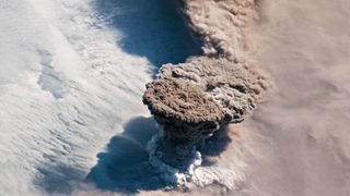
A volcano rumbled to life
Advertisement
(Image credit: NASA Earth Observatory)
The Raikoke volcano, a remote mountain on the archipelago of volcanic peaks between Russia’s Kamchatka peninsula and Japan’s Hokkaido Island, had been quiet since 1924 — until this year. On June 22, Raikoke blew its top, sending a mushroom-shaped cloud of ash 43,000 feet (13 kilometers) into the atmosphere.
The remoteness of the eruption meant that it seriously affected only air travel, forcing planes to divert to avoid the ash cloud. But an employee on a cruise ship that came close to the island the day after the eruption was able to photograph the sudden change in the once-sleepy volcano. The slopes of the mountain were covered with inches of thick, light ash, and flows of ash and debris many feet thick had traveled down the volcano’s flanks, according to the Smithsonian Institution’s Global Volcanism Program. The island’s vegetation was smothered in the ash.
PROMOTED BY TEDDYFEED
SPONSORED
T
READ MORE
T
[Gallery] This Wedding Dress Made Guests Truly Uncomfortable
TEDDYFEED.COM
Earthquake Island vanished
Advertisement
(Image credit: Newscom)
As quickly as it arrived in 2013, Pakistan’s “Earthquake Island” disappeared in 2019.
Earthquake Island was produced during a 7.7-magnitude earthquake that killed more than 800 people in southwestern Pakistan in September 2013. As the Arabian tectonic plate and the Eurasian plate ground together, buried mud shot toward the surface, carrying rocks and boulders with it. The resulting island protruded 65 feet (20 m) above the ocean surface, and measured 295 feet (90 m) wide and 130 feet (40 m) long.
This year, erosion wiped away all but a few sediment traces of Earthquake Island. NASA researchers say that this short life span is common for islands produced by “mud volcanoes,” the term for deep mud and rock being ejected through fissures in the crust.
Dorian devastated the Bahamas
(Image credit: NOAA)
On Sept. 1, 2019, Hurricane Dorian rolled over the Bahamas as a slow-moving Category 5 storm, subjecting the Abacos Islands and Grand Bahama Island to hours of heavy rains and winds topping out at 185 miles per hour (295 km/h). On Sept. 3, as the storm moved away, 60% of Grand Bahama Island was underwater, according to satellite imagery captured by the Finnish firm ICEYE SAR Satellite Constellation.
The hurricane devastated the human infrastructure on the islands and killed dozens of people. The storm also damaged much of the Bahama’s natural ecosystem, tearing up trees and threatening wildlife that relies on the islands’ ecology. Scientists worry that the disturbance may have killed the last Bahama nuthatches (Sitta pusilla insulari) in the world. These small birds, which are found only on Grand Bahama, were down to just a few individuals after Hurricane Matthew hit the island in 2016. It’s unconfirmed if any of the birds made it through Hurricane Dorian, but the monster storm and saltwater flooding hit the birds’ forest habitat hard, leading to fears that Dorian was the nail in the coffin for this rare and endangered species.
As the Atlantic reeled from Dorian, the Pacific experienced a marine heatwave of unusual significance. The event in the Pacific was a near-repeat of “The Blob,” a huge expanse of unusually warm water that persisted off the U.S. west coast from 2013 to 2016. According to the California Current Marine Heatwave Tracker, the 2019 version of the blob was nearly as large and warm as the previous event, which affected salmon and other marine life. Sea-surface temperatures in the blob were 5.4 degrees Fahrenheit (3 degrees Celsius) hotter than average.
These heat waves are, by definition, transitory events, not permanent increases in sea temperature. But scientists are increasingly worried that these heat events will become the new normal. “We learned with ‘the Blob’ and similar events worldwide that what used to be unexpected is becoming more common,” Cisco Werner, director of scientific programs at the National Oceanic and Atmospheric Administration, said in a NOAA news piece released in September.
Antarctica lost a tooth
Advertisement
(Image credit: ESA Sentinel-1A)
Better late than never? An iceberg that scientists expected to crack off Antarctica by 2015 finally made its move in September.
The chunk of ice 632 square miles (1,636 square kilometers) in size rifted from the icy continent on Sept. 26;.it broke off the Amery Ice Shelf in East Antarctica. That ice formation seems to calve large ‘bergs every 60 to 70 years, scientists reported.
Despite the change in Antarctica’s coastline, the iceberg was already floating, so its calving did not affect sea levels. However, ice loss in Antarctica is accelerating — scientists estimate that the continent has lost 3 trillion tons in the last 25 years, translating to 0.3 inches (8 millimeters) of sea-level rise.
The atmosphere got more carbon-rich
(Image credit: Shutterstock)
Advertisement
Perhaps the most far-reaching change to the planet in 2019 was the continued pumping of carbon into the oceans and atmosphere, which hit a record high this year.
According to a report by the Global Carbon Project, human activity — from agriculture to transportation to industry — emitted approximately 43.1 billion tons of carbon in 2019. That makes 2019 a record-setter, breaking the previous high set in 2018. Excess carbon in the atmosphere remains there for decades to centuries, so the emissions released in 2019 will reverberate far into the future. According to the Intergovernmental Panel on Climate Change (IPCC), without a rapid reduction of greenhouse gas emissions, the atmosphere is expected to warm 5.4 F (3 C) above pre-industrial levels by 2100.
The awful news that all but two penguin chicks have starved to death out of a colony of almost 40,000 birds is a grim illustration of the enormous pressure Antarctic wildlife is under. The causes of this devastating event are complex, from a changing climate to local sea-ice factors, but one thing penguins, whales and other marine life don’t need is additional strain on food supplies.
Over the next year we have the opportunity to create an Antarctic Ocean Sanctuary – the largest protected area on Earth – which would put the waters off-limits to the industrial fishing vessels currently sucking up the tiny shrimp-like krill, on which all Antarctic life relies.
In 1990, the Voyager 1 space probe looked back at Earth from six billion kilometres away and took a historic selfie of our solar system. What it saw, according to renowned astrophysicist Carl Sagan, was a “pale blue dot”.
“Our planet is a blue planet,” echoed David Attenborough, in his opening words to the BBC’s landmark Blue Planet series. With over 70% of our world covered by water, this is no exaggeration. Our oceans can be seen from across the solar system.
The majority of this water falls outside of national borders. In fact, almost half of our planet is a marine natural wonder outside the boundaries of flags, languages and national divisions. These vast areas cover 230 million square kilometres, and they belong to us all. To give a sense of scale, that’s the size of every single continent combined, with another Asia, Europe and Africa thrown in for good measure. The size of our oceans may seem overwhelming. Our collective responsibility to protect them, however, should not.
It wasn’t long ago that the oceans were thought to be too vast to be irrevocably impacted by human actions, but the effects of overfishing, oil drilling, deep sea mining, pollution and climate change have shown that humans are more than up to the task of imperilling the sea and the animals that live there.
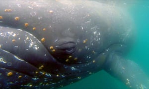
A humpback whale dives for krill in Wilhelmina Bay, off the Antarctic Peninsula. ‘The creeping expansion of industrial fishing is targeting the one species on which practically every animal in the Antarctic relies: krill.’ Photograph: Charles Littnam/WWF/EPA
All of us who live on this planet are the guardians of these environments, not only to protect the wildlife that lives in them, but because the health of our oceans sustains our planet and the livelihoods of billions of people.
Here’s the good news. The tide of history is turning. We on the blue planet are finally looking seriously at protecting the blue bits. Just a few months ago, in a stuffy room far from the sea, governments from around the world agreed to start a process to protect them: an ocean treaty.
This ocean treaty won’t be agreed until at least 2020, but in the meantime momentum is already building towards serious and binding ocean protection. Just last year a huge 1.5 million sq km area was protected in the Ross Sea in the Antarctic. In a turbulent political climate, it was a momentous demonstration of how international cooperation to protect our shared home can and does work.
Over the next two weeks, the governments responsible for the Antarctic are meeting to discuss the future of the continent and its waters. While limited proposals are on the table this year, when they reconvene in 12 months’ time they have a historic opportunity to create the largest ever protected area on Earth: an Antarctic Ocean sanctuary. Covering the Weddell Sea next to the Antarctic peninsula, it would be five times the size of Germany, the country proposing it.
The Antarctic is home to a great diversity of life: huge colonies of emperor and Adélie penguins, the incredible colossal squid with eyes the size of basketballs that allow it to see in the depths, and the largest animal on the planet, the blue whale, which has veins large enough for a person to swim down.
The creeping expansion of industrial fishing is targeting the one species on which practically every animal in the Antarctic relies: krill. These tiny shrimp-like creatures are crucial for the survival of penguins, whales, seals and other wildlife. With a changing climate already placing wildlife populations in the Antarctic under pressure, an expanding krill industry is bad news for the health of the Antarctic Ocean. Even worse, the krill industry and the governments that back it are blocking attempts at environmental protection in the Antarctic.
Ocean sanctuaries provide relief for wildlife and ecosystems to recover, but it’s not just about protecting majestic blue whales and penguin colonies. The benefits are global. Recovering fish populations spread around the globe and only now are scientists beginning to fully understand the role that healthy oceans play in soaking up carbon dioxide and helping us to avoid the worst effects of climate change. Sanctuaries encourage vital biodiversity, provide food security for the billions of people that rely on our oceans, and are essential to tackling climate change. Our fate and the fate of our oceans are intimately connected.
Creating the world’s largest ever protected area, in the Antarctic Ocean, would be a signal that corporate lobbying and national interests are no match for a unified global call for our political leaders to protect what belongs to us all. The movement to protect over half our planet begins now, and it begins in the Antarctic.
Now floating northwest of the South Georgia islands near the tail of South America, the iceberg — named B-15 — has traveled more than 6,600 miles (10,000 kilometers) from the ice shelf and is veering dangerously close to the equator. [Photos: Diving Beneath Antarctica’s Ross Ice Shelf
Satellite images taken from the International Space Station (ISS) on May 22 confirm that the remains of the iceberg are on a crash course with warm tropical waters, where growing pools of meltwater will soon “work [their] way through the iceberg like a set of knives,” NASA glaciologist Kelly Brunt said in a statement.
The freewheelin’, formerly Connecticut-size iceberg first embarked on its long cruise after breaking away from the Ross Ice Shelf in 2000, NASA said. At the time, it was the largest single chunk of ice ever to split off from the shelf, measuring 160 nautical miles long and 20 nautical miles wide. (That’s a total area of 3,200 square nautical miles — larger than the island of Jamaica.)
Iceberg B-15 broke off of the Ross Ice Shelf in 2000, floated three quarters of the way around Antarctica and is now veering north toward its doom.
Credit: NASA/ International Space Station
Currents swept the berg three-quarters of the way around Antarctica; then, it suddenly shifted northward into the southern Atlantic Ocean within the past year or two, NASA said.
The stately raft of ice has gradually splintered into many smaller pieces, most of which have already melted. Today, only four chunks remain with a large enough surface area to be trackable by the National Ice Center (20 square nautical miles is the minimum).
The chunk observed from the ISS last month (its name is B-15Z) still has a surface area of about 50 square nautical miles, but it is likely nearing the end of its journey as it floats ever closer to the equator. According to NASA, icebergs have been known to rapidly melt once they drift into this region. A large fracture is already visible at B-15Z’s center, and smaller pieces are crumbling away from its edges.
B-15 will be missed. But its fans may take solace in knowing that, thanks to climate change, another “largest iceberg ever” will probably break away soon enough.