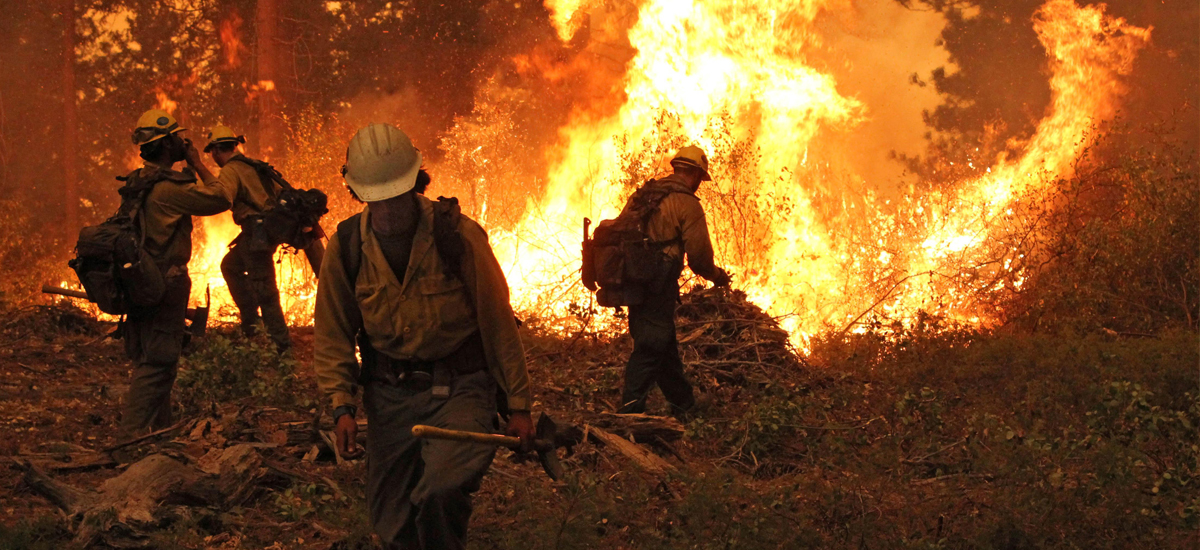
The effects of global warming on temperature, precipitation levels, and soil moisture are turning many of our forests into kindling during wildfire season.
These hot, dry conditions also increase the likelihood that wildfires will be more intense and long-burning once they are started by lightning strikes or human error.
The costs of wildfires, in terms of risks to human life and health, property damage, and state and federal dollars, are devastating, and they are only likely to increase unless we better address the risks of wildfires and reduce our activities that lead to further climate change.
Wildfires are already on the rise
Wildfires in the western United States have been increasing in frequency and duration since the mid-1980s. Between 1986 and 2003, wildfires occurred nearly four times as often, burned more than six times the land area, and lasted almost five times as long when compared to the period between 1970 and 1986.
Natural cycles, human activities like land-use change and fire exclusion, and human-caused climate change can all influence the likelihood of wildfires. Many of the areas that have seen increased wildfire activity, like Yosemite National Park and the Northern Rockies, are protected from or relatively unaffected by human land-use change, suggesting that climate change is a major factor driving the increase in wildfires in these places.
Precipitation patterns, global warming, and wildfires
Though the current trend of increasing severe wildfire frequency in parts of the US is projected to continue as the climate warms, droughts and wildfires are not equally likely to occur every year.
Natural, cyclical weather occurrences such as El Niño events also affect the likelihood of wildfires by affecting levels of precipitation and moisture and lead to year-by-year variability in the potential for drought and wildfires regionally.
Nonetheless, because temperatures and precipitation levels are projected to alter further over the course of the 21st century, the overall potential for wildfires in the western United States is projected to increase.
As the world warms, we can expect more wildfires
US wildfire seasons—especially those in years with higher wildfire potential—are projected to lengthen, with the Southwest’s season of fire potential lengthening from seven months to all year long. Additionally, the likelihood that individual wildfires become severe is expected to increase.
Researchers project that moist, forested areas are the most likely to face greater threats from wildfires as conditions in those areas become drier and hotter.
Surprisingly, some dry grasslands may be less at risk of catching fire because the intense aridity is likely to prevent these grasses from growing at all, leaving these areas so barren that they are likely to lack the fodder for wildfires to start and spread.
A conflagration of costs
The economic costs of wildfires can be crippling. Data on total US property damage from wildfires are hard to come by, but the costs are estimated to be on the level of hundreds of millions of dollars per year.
In addition to property damage, wildfires cost states and the federal government millions in fire-suppression management. The US Forest Service’s yearly fire-suppression costs have exceeded $1 billion for 13 of the 18 years between 2000 and 2017. In 2015, these costs exceeded $2 billion, and in 2017 they totaled almost $3 billion. The risk to property owners is particularly acute in areas at the “wildland-urban interface.” In California alone, this area includes more than 5 million homes in coastal southern California, the Bay Area, and northeast of Sacramento.
The environmental and health costs of wildfires are also considerable. Not only do wildfires threaten lives directly, but they have the potential to increase local air pollution, exacerbating lung diseases and causing breathing difficulties even in healthy individuals.
Greenhouse-gas emissions from human activities are raising global temperatures and changing the climate, leading to a likely rise in wildfire severity and frequency.
But it is not too late to act. What we do now has the power to influence the frequency and severity of these fires and their effects on us.
By engaging in fire safety efforts—creating buffer zones between human habitation and susceptible forests, and meeting home and city fire-safety standards—we can help reduce our current risks, and by taking steps to reduce our impact on the climate, we can help to keep our forests, our homes, and our health safe.
Smoke from wildfires in British Columbia, Eastern Washington and Montana enshrouds the Cascade Mountains of Washington State. In the Pacific Northwest, experiencing weeks on end of wildfire smoke during the summer months has become the “new normal.”DAHR JAMAIL
Over the years, writing these climate disruption dispatches has often weighed heavily on my soul. I’ve struggled to find a delicate balance between tracking this information, which these days means reporting on the demise of the biosphere, and living a meaningful life.
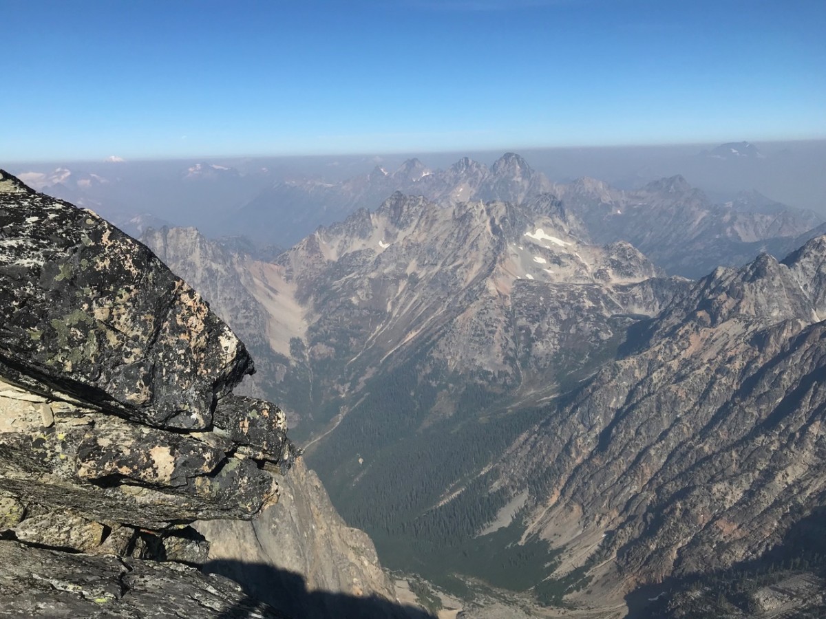
Recently, I again failed to achieve that balance, and needed to take a short respite from work to find my inner footing. I headed into my sanctuary, the mountains, for solace. I backpacked up into the northeastern Cascade Mountains of Washington State, where I live, and pitched a camp on the banks of a clear, turquoise alpine lake at 6,900 feet. I was surrounded by snowfields, high peaks, and mountain larch that will soon be turning from green to yellow as autumn rapidly approaches.
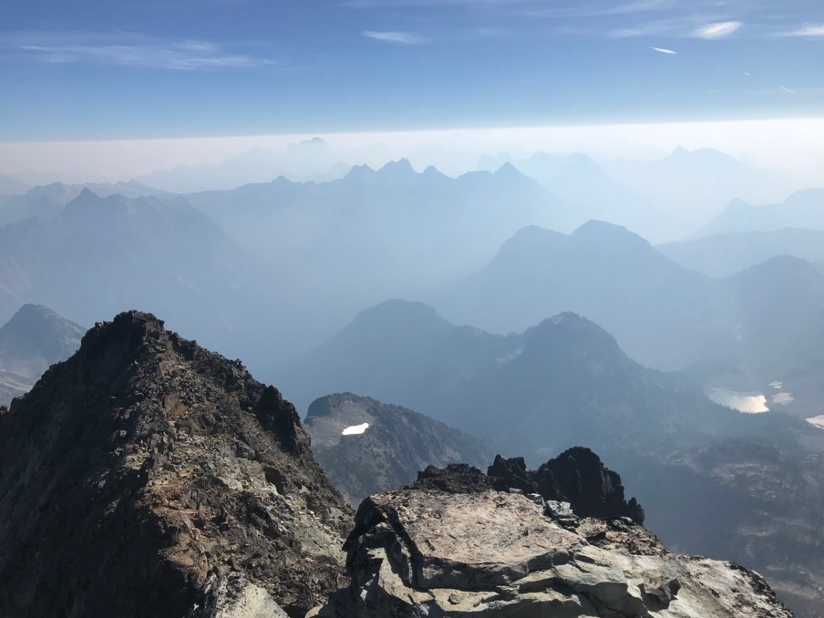
Despite smoke in the air from wildfires in Canada, eastern Washington, and beyond, conditions were beautiful. The next day I scrambled to the top of nearby Black Peak, but did so as the smoke became increasingly thick. My lungs felt scratchy, my eyes burned, and I could tell it was affecting my thinking. Atop the peak at 8,975 feet found me at roughly the elevation of the smoke line. Above were crystal clear blue skies; below, everything was shrouded in a brownish-grey sooty haze.
Wildfire smoke covering the Cascade Mountains from 9,000 feet and below. As anthropogenic climate disruption progresses, science shows wildfires becoming larger, burning hotter and occurring far more frequently.DAHR JAMAIL
After taking lunch on the summit and reveling in the majestic yet smoky views, I headed back down to camp, where the smoke was rolling in by way of thick clouds. I decided to break camp a day early and hike down to the trailhead to head to my home near the west coast, hoping the smoke might not be as thick closer to the Pacific.
Don’t miss a beat
Get the latest news and thought-provoking analysis from Truthout.
Two hours of driving later, the haze wasn’t as thick, but remained present. Not until I boarded the ferry and crossed the Strait of Juan de Fuca across Puget Sound did I finally emerge from the suffocating wildfire smoke.
The feeling of entrapment within the smoke, the coughing and wheezing while trying to breathe, the primal urge to escape it, all underscored to me how dire our situation is globally. Arriving back home, out of the smoke, I thought of future summers. Even up here in the verdant Pacific Northwest, wildfire smoke will be the norm. Yet, compared to those who’ve already lost their homes to the fires, or those who’ve had everything they own submerged by storm surges from hurricanes, or refugees fleeing war-torn countries destabilized by drought and climate disruption impacts, smoke inhalation is a minor problem. Such is the climate-triage of our new world.
Moreover, the impacts of runaway anthropogenic climate disruption (ACD) will assuredly continue to worsen.
In one of the more important recent scientific studies, published in the journal Science, researchers warn that ACD could cause many of the planet’s ecosystems to become unrecognizable.
“Our results indicate that terrestrial ecosystems are highly sensitive to temperature change and suggest that, without major reductions in greenhouse gas emissions to the atmosphere, terrestrial ecosystems worldwide are at risk of major transformation, with accompanying disruption of ecosystem services and impacts on biodiversity,” reads the abstract of the study.
Stephen Jackson, the lead author of the study, told The Washington Post, “Even as someone who has spent more than 40 years thinking about vegetation change looking into the past … it is really hard for me to wrap my mind around the magnitude of change we’re talking about.”
This summer’s extraordinary heat wave across the Northern Hemisphere was and is in no way an anomaly. Another recent study warned that there will be at least four more years of extreme temperatures. This means temperatures are expected to be warmer than expected, even above and beyond the abnormal warming being generated by ACD.
Given the fact that there are already places in the Arctic where the ground no longer freezes, even during the winter, this does not bode well.
Another recent report, What Lies Beneath: The Understatement of Existential Climate Risk by Australian researchers with the independent think tank National Centre for Climate Restoration, is blunt about the fact that we are rapidly leaving the safe zone for human habitability on the planet. They note that ACD poses an “existential risk to human civilization,” with dire consequences unless dramatic actions are taken toward mitigation. The paper also points out how climate research, including the work of the Intergovernmental Panel on Climate Change (IPCC), has consistently underplayed these risks and leaned towards conservative projections. The paper even goes on to call the IPCC “dangerously misleading” regarding its low-ball predictions of accelerating ACD.
“Climate change is now reaching the end-game,” the foreword to the report reads, “where very soon humanity must choose between taking unprecedented action, or accepting that it has been left too late and bear the consequences.”
One only need look at this past summer to see that we have, indeed, reached the end-game.
Earth
You know the Earth’s climate is warming extremely dramatically when a tree that used to grow in a warmer Alaska several million years ago is once again growing there. The tree requires warmer temperatures to grow, which are now once again occurring in Alaska.
Warming is now putting our food supply in grave danger. Globally, we are already seeing a weaker wheat crop this year due to record-breaking high temperatures around the world. It’s been well known for quite some time that higher carbon dioxide (CO2) levels in the atmosphere cause crops to be less nutritious, but researchers recently warned that the scope of the problem means hundreds of millions more people than previously thought will now be nutrient deficient as temperatures continue to climb. The research showed that 1.4 billion women of childbearing age, along with children less than five years old, will be living in regions with the highest risk of iron deficiency.
Making matters worse, another recent study warned that global crop losses due to increasing pests will soar as temperatures continue to climb. The study projects that increasing heat causes the number of insects — and the amount they eat — to grow, so that nearly 50 percent more wheat will be destroyed from just a 2°C increase in temperatures, along with 30 percent more maize and 20 percent more rice.
Another recent report revealed how in the Mojave Desert region in California and Nevada, there has been a precipitous (42 percent) decline in bird species in the past century alone, likely due to the impacts of ACD.
The heat in Europe this summer was intense enough that 22 people died from the West Nile virus there, as experts warned of more mosquito and tick-borne disease outbreaks as temperatures there continue to increase.
Another report warned of how high temperatures and increasing air pollution may well increase the risk of mental illnesses and suicide. Having recently spent days living amidst the thick smoke of wildfires, I can understand this warning, given the way in which experiences of this nature affect the psyche.
Water
Climate impacts across the Arctic continue to sound alarm bells with scientists.
At the time of this writing, at least 36 people have died from the impacts (mostly flooding) from Hurricane Florence that struck the US east coast.Days after it made landfall, rainfall persisted — 40 inches of rain in North Carolina alone — and rivers continued to swell, as thousands of homes and businesses were affected by record flooding that besieged several states. As the atmosphere warms, hurricanes now generate increasingly severe rain events, along with packing stronger winds from the increased energy produced by the warmer air and warmer waters over which they travel.
The oldest, thickest and strongest sea ice in the Arctic, which has never opened up in recorded history, has melted open twice this year … an occurrence that scientists have described as “scary.” Sea ice in that region is shrinking so much now that over the summer, for the first time, a container ship took the Arctic sea route.
Researchers recently announced that a pocket of warm ocean water under the surface of the Canada Basin could melt a large portion of the region’s sea ice, warning that the situation is a “ticking time bomb.”
Back on land, mountaineers in Europe are bemoaning the fact that ACD is literally melting the French Alps, causing rocks to become unstable and more prone to collapse as permafrost and ice melt.
Meanwhile, the oceans continue to warm unabated. In August off the coast of San Diego, scientists recorded an all-time high temperature of seawater, causing scientists to warn that much sea life is now “in peril.” The number of marine heatwaves doubled between 1982 and 2016.
Scientists have also warned of “unprecedented” changes to Japan’s marine life as atmospheric CO2 and acidification both continue to increase.
As land-ice melts and oceans warm, sea levels continue to rise unabated as well.
Jakarta, a mega city of more than 10 million, has now become known as the fastest-sinking city in the world. Large parts of the capital of Indonesia will be completely submerged by just 2050, and parts of it are already disappearing underwater. As Jakarta and other major coastal cities begin to be swallowed by the seas, we must ask: Where will these millions of people go?
Things aren’t much better in Europe, where a recent analysis showed that the cost of coastal flooding there could reach $1 trillion annually by 2100 if current trends continue. At the moment, there is no reason to think they will not.
Bangkok, another city of at least 10 million, is struggling to stay above water as some forecasts warn that large portions of it could be submerged in just over 10 years.
In India, while the monsoon is a regular event and always brings flooding, it is clearly amped up due to ACD impacts. Flash flooding in the southern Indian state of Kerala resulted in the death of at least 324 people, which officials there declared to be the worst in at least the last century.
In the US, historic flooding hit the northeast that same month, causing New Jersey to declare a partial state of emergency and evacuations occurred.
A recent study warned that the US West could experience three times as much destructive flooding if ACD is left unchecked, with communities in the Rocky Mountain and Sierra Nevada ranges at particular risk from rapidly flooding rivers and “rain-on-snow” flash floods that are predicted to become more frequent.
Meanwhile, droughts continue around the world.
A drought in Switzerland was bad enough this summer that the Swiss army had to airlift water to thirsty cows in pastures that were plagued with drought amidst the intense heat wave that swept that continent this summer.
You don’t need to read this dispatch to know this summer has been exceptional for wildfires.
At one point, Canada’s British Columbia had 566 wildfires burning across it, causing the province to declare a state of emergency that prompted thousands of people to evacuate. That declaration was then extended as the fires continued, with 2018 becoming the worst fire season on record(breaking the previous record, set just last year) for British Columbia. The warmer the atmosphere becomes, the longer, hotter and drier wildfire season becomes in British Columbia, as well as around the rest of the world.
Smoke from those fires, along with hundreds of others across the US West was visible from, literally, a million miles away in space.
In California something occurred never before seen in the history of wildfires in that state: A literal tornado of fire the size of three football fields emerged, as vast areas of that state burned in what has become a normal situation there during the summers, thanks largely to ACD.
Things were bad enough in Washington State that at one point western Washington saw its worst air quality on record. Because of the wildfires, in late August, Spokane had worse air quality than Beijing and Delhi combined.
Air
It is only a matter of time before several cities begin to see 50°C (122°F) temperatures — which is halfway to boiling — on a regular basis. This spring, Nawabshah, Pakistan, and two years before that Phalodi, India, both experienced 50°C. Bear in mind that even 35°C (95°F) temperatures, along with humidity, can be fatal to humans after just a few hours. A recent report warns that temperatures of at least 35°C will likely become common across India, Pakistan, southeast Asia and China sooner rather than later, with half the world’s population exposed to potentially deadly heat for 20 days a year by 2100.
Simultaneously, increasingly warm temperatures around the globe have sparked yet another feedback loop: Warmer temperatures are causing soil to release more CO2 into the atmosphere, which then causes temperatures to increase further.
Lastly in this section, to give you an idea of the intensity of this summer’s heat wave, Korea’s Ministry of Agriculture, Food and Rural Affairs reported recently that 4.53 million cows, ducks, pigs, chickens and other farm animals died from the heat wave that swept that country. This was a 56.5 percent increase over the number of animals killed by the heat last year during the same time period.
Denial and Reality
The usual ACD denial from the Trump administration continues, despite the planet spiraling deeper into abrupt ACD impacts daily.
During a visit to the apocalyptic Redding fire zone in California, Trump administration officials Agriculture Secretary Sonny Perdue and Interior Secretary Ryan Zinke refused to talk about ACD when it came to how to address the worsening wildfires.
The Trump administration also proposed a new rule that relaxes carbon limits on power plants, which allows the plants to run longer. The EPA’s own analysis has shown that this step could lead to 1,400 more premature deaths by 2030 due to the pollution. Explicit warnings about ACD impactswere also cut from the Trump administration plan to weaken curbs on power plant emissions.
Meanwhile, big oil has asked the federal government to protect its infrastructure from the impacts of ACD, as Texas aims to acquire billions of dollars of federal funding to build up its coast in an effort to protect its oil infrastructure from hurricanes, flooding and sea level rise.
On the reality front, the State of California recently passed legislation, including steps to take to make it happen, geared toward the cessation of using fossil fuels to generate electricity by the year 2045.
Yale’s climate change communication program released an up-to-date visualization showing that the vast majority of Americans believe ACD is real, as well as a graphic that enables one to focus in on the parts of the country where willful ignorance is the most rampant.
Things are already dire enough that several countries in the Caribbean recently pleaded with the Trump administration to grasp the dire threats that accompany ACD and do something about it. So far, of course, their pleas have not been answered with action.
A fascinating graphic was also published by The Revelator, which provides an interactive map you can use to zoom in on where you live to see how much your temperatures will increase by the year 2050. I strongly recommend looking at the map, paying particular attention to the US Midwest, given the realities of crop loss and decreasing nutrition in crops.
To conclude this month’s dispatch, a UN official recently announced that governments are “not on track” to cap global temperatures to below 2°C, the goal of the 2015 Paris climate talks. Many scientists have long warned that a 1°C warming was already enough to lock in catastrophic ACD impacts. We are already over 1°C. The ongoing failure of the world’s governments to face these facts guarantees a lasting and devastating impact for all species on Earth, including humans.
After a wildfire, one rescue worker says she often treats bears suffering from dehydration and malnutrition
Joel Ballard · CBC News ·
Angelika Langen seen treating a bear cub in an undated photo. She says she’s preparing to treat a number of malnourished bears who have lost access to food due to the B.C. wildfires. (Angelika Langen)
Angelika Langen has been rehabilitating bears at the Northern Lights Wildlife Society in Smithers, B.C., for 27 years.
But this summer proved especially difficult, after a number of animals she’d been treating died unexpectedly. With each death, she could feel her resolve crack.
“That takes a huge chunk out of your heart every time,” said Langen, who lives outside of the northern B.C. town.
Sometimes the loss leads her to consider quitting.
“But then there’s another animal that comes and you just pick back up again and on you go.”
After B.C.’s record-setting wildfire season, Langen is bracing to treat a number of animals, specifically bears, that have been displaced by the blazes.
While many people across the province have been forced to flee their homes due to wildfires, so too have wildlife. Fires rip through forests, destroying habitats and burning food sources.
Forced from homes
It’s not often that Langen treats a bear with a direct injury from a wildfire, but the indirect effects keep her busy.
When a bear is forced out of its territory, it will move in search of a new home. However, that new home may already be inhabited, at which point the bears will fight each other to lay claim to the patch of land.
Usually, the weaker bear will be pushed further away in search of food, creating a ripple effect, according to Langen, until it wanders into an urban area, sniffing out garbage cans for food. This represents a danger to the public and to the bear.
After a wildfire, Langen says she often treats bears suffering from dehydration and malnutrition.
Angelika Langen will keep malnourished bears at her shelter until they put on enough weight to be released into the wild. (Video by Northern Lights Wildlife Society)
A natural force of renewal
Although wildfires often cause disruption and harm to people and wildlife, there is a small silver lining, said Cole Burton, a University of British Columbia assistant professor of forestry.
“Fire is a natural force of renewal in the ecosystem,” said Burton.
He says a fire can clear out bigger vegetation and lead to the germination of seeds in the soil, creating conditions that allow certain plants to grow better.
“Sometimes that new growth is very nutritious and abundant, high-quality forage,” said Burton.
Cole Burton says fire can clear out bigger vegetation and lead to the germination of seeds in the soil, creating different conditions that allow certain plants to grow better. (@CONAFOR/Twitter)
How to help?
Langen typically sees bears in need of aid once the wildfires have ended, so she’s using this period to remind the public that the best way to help is to leave bears alone.
Too often, someone will see a skinny bear and leave out food or water, she said. Very quickly, the bear will learn to expect food and eventually return for more.
“Even though you feel bad, you really need to make sure that you do not give that kind of assistance because it does not lead to a good end,” said Langen.
The Ministry of Forests, Lands, Natural Resource Operations and Rural Development announced today that two areas affected by wildfire in the Cariboo will be closed to moose hunting from Oct. 15-31 and Nov. 1-15.
The closures affect an area north of Highway 20 and west of Williams Lake and Quesnel, after the Chilcotin Plateau Fire ravaged the area this summer. The press release noted that the area is also important to First Nations sustenance hunting.
Doug Donaldson, Minister of Forests, Lands, Natural Resource Operations and Rural Development, said: “This has been an unprecedented wildfire season, with parts the Cariboo particularly hard hit. With moose populations already declining in this management zone, we need to take steps now to protect wildlife and ensure healthy moose populations in the future.”
The closure comes after First Nations groups in the region called for the province to instate a moratorium on moose hunting.
Contacted for comment, Nazko First Nation chief Stuart Alec said: “It’s great news to hear that the province is taking steps to address the situation and the concerns of the Nazko people and others concerned about the moose populations.
“We are looking forward to working further with the province to maintain moose populations in the region.
“We have not been hunting in the wildfire zones, and are focusing our hunts north of the Blackwater River.”
The ministry indicated that the areas impacted by the hunting ban will be assessed over the winter to inform what level of sustainable hunting will be available in the coming years.
13,000 livestock, mostly cattle, have been in areas affected by evacuation orders and alerts
The Canadian Press ·
Cattle run on a ranch as the Shovel Lake wildfire burns in the distance sending a massive cloud of smoke into the air near Fort St. James. (Darryl Dyck/Canadian Press)
British Columbia’s agriculture minister says critical lessons learned from last year’s wildfires that had ranchers and producers suffering devastating losses will help save animals during another season that could force more people from their properties.
Lana Popham said Wednesday the province’s premises identification program, which was meant to trace cattle back to an operation during a disease outbreak, allowed animals to be rescued last year after evacuation orders were issued.
“As the fires increased last summer and this program seemed to have so much value we saw those numbers increase significantly,” she said of more farmers and ranchers registering for the program.
“That’s allowing us to get into areas that have been identified as heavy agricultural, livestock areas and be able to assess a situation and move those animals out as needed.”
In some cases, grazing cattle remained safe in certain areas after ranchers have left due to encroaching fires, Popham said, adding 35,000 livestock were on the loose last year at the height of the worst wildfire conditions.
“This program allows them to re-enter into evacuation zones and tend to their livestock so it’s extremely important for people to be registered for this program and I think over the last two years, especially, that message has hit home.”
So far this season, 13,000 livestock, mostly cattle but also sheep, horses and pigs, have been in areas affected by evacuation orders and alerts, Popham said, adding ministry staff are working with the B.C. Cattlemen’s Association to co-ordinate alternate grazing sites, organizing emergency feeds and helping with the relocation of animals.
“We won’t often know if they’ve been lost until they don’t come home later in the fall,” Popham said. “I have heard reports of cattle that have been burned, but no numbers on that yet.”
Williams Lake is one of the hardest-hit areas, Popham said.
“The emotional toll that these farmers and ranchers are feeling is tremendous. And we saw this last year. You see some of the strongest farmers you know break down when they realize some of their animals aren’t coming home.”
After the 2017 wildfires, the federal government provided $20 million in funding to help farmers and ranchers, but Popham said her ministry has not made any requests for financial help so far this year as it awaits assessments on areas that weren’t affected last year.
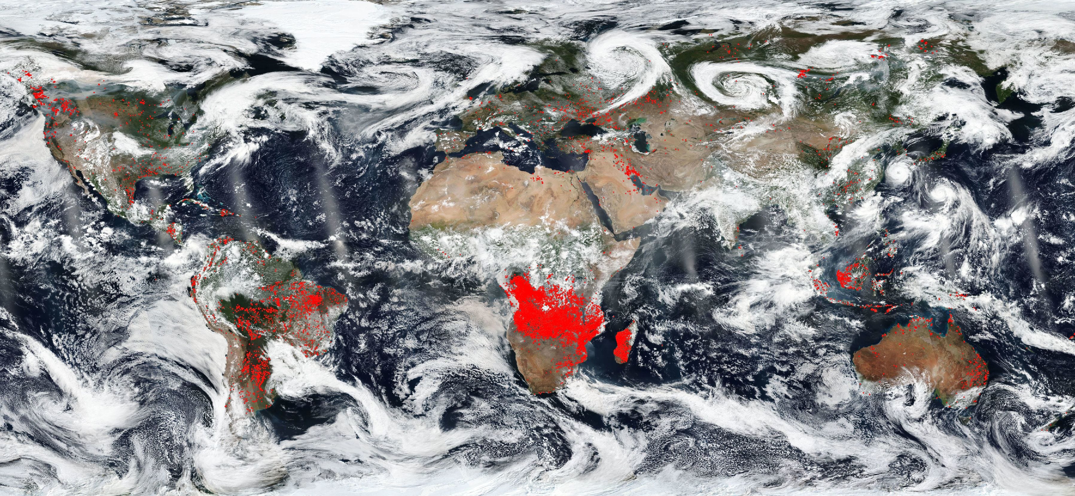
Satellite imagery of Earth is cool because it gives us a different perspective of our home, but it can also be quite disturbing. This week on Twitter, NASA shared an image that shows not only brown and green continents, vast oceans, and swirling white clouds, but also red dots that show a large number of fires currently burning over the world.
The red blobs are most concentrated in central Africa, but extend to parts of every other continent except for Antarctica. “The world is on fire,” read NASA’s tweet. In a blog post, the agency explained that the image was taken using the Earth Observing System Data and Information System (EOSDIS) Worldview, and that the areas that appear to be completely engulfed in flames were detected by thermal bands and are likely from agricultural burns. “The location, widespread nature, and number of fires suggest that these fires were deliberately set to manage land,” NASA writes. “Farmers often use fire to return nutrients to the soil and to clear the ground of unwanted plants. While fire helps enhance crops and grasses for pasture, the fires also produce smoke that degrades air quality.”
Other areas of red are likely wildfires, like the ones that continue to ravage parts of California. Northern Africa is largely untouched because there is not much to burn in the Sahara, and the poles are fine because of the low temperatures. NASA’s Worldview website allows users to go back in time to see how the burning areas have changed over the course of the summer, and there is even a feature that will animate a set period of time so that you can watch the red dots accumulate. The site also tracks major events like volcano eruptions, iceberg splits, and typhoons. The purpose is obviously not to revel in the destruction of the Earth as seen from above, but there is something cool about seeing the planet from this perspective and being able to witness its changes over time while tracking their natural and human causes.
The Alkali Lake and South Stikine River fires have merged, now engulfing almost 300 square kilometres of northwestern B.C. (B.C. Wildfire Service)
Vernon Marion had two hours to prepare to flee when he got the evacuation order to leave his home in Telegraph Creek, B.C., earlier this week as the Alkali Lake wildfire roared closer.
He ran outside, put some of his belongings in a field he thought would be safe from the fire, and tried to protect them with a tarp and water jugs.
“You don’t think properly when something like that’s happening,” he said.
“If you had to do it all over again you’d probably do it differently.”
Vernon Marion of Telegraph Creek, B.C., is concerned about the 30 horses he had to leave behind when he was evacuated from his home as a wildfire approached. (Philippe Morin/CBC)
Neighbours and outfitters have offered to take horse trailers into the area to rescue the animals, but officials told Marion it’s too dangerous.
So now he has to wait and find out what is to become of his ranch and his horses.
“We’ll go down there if we get a break [Friday] and round them up.”
‘We’re resilient’
Yukon Minister of Tourism and member of the Tahltan First Nation Jeanie Dendys was in Telegraph Creek during the evacuation where she and her sister helped people get out of the community.
“Our chief is working non-stop which is what we did during those initial days,” she said.
“There’s so much work to be done, but people are safe and that was what our main focus was.”
Dendys said the Tahltan people are heartbroken over the devastation the wildfire has caused in their region, but she believes the strength of the community will help them overcome the loss.
“We’re resilient,” she said. “The unity that we have among our people will bring us through this.”
Fires merged
Early Thursday, the South Stikine River and Alkali Lake fires merged created a fire covering almost 300 square kilometres.
At a meeting in Dease Lake on Wednesday night, B.C. Wildfire Service incident commander Hugh Murdoch said ground crews and air support are working to protect culturally significant sites and buildings in the area.
From left, Tony Falcao of the B.C. Wildfire Service, Chief Rick McLean of the Tahltan Nation and Hugh Murdoch of the B.C. Wildfire Service update the public on the fire situation on August 8, 2018. (Phillipe Morin/CBC)
“The type of efforts that we’ve been putting forward will continue,” Murdoch said.
A cold front is expected to pass through the area in coming days, and crews are preparing for a potential increase in wind and shift in its direction.
A C-130 air tanker drops flame retardant on part of the Mendocino Complex Fire in California on August 5, 2018. Noah Berger/AFP/Getty Images
The 2018 wildfire year has been devastating. As of Monday, the National Interagency Fire Center reports that there are 60 uncontained large fires across the country, with a total of 5.1 million acres ravaged by fire so far this year.
These deadly infernos have killed several firefighters, forced hundreds of people to flee, and destroyed hundreds of homes and thousands of acres of wilderness.
The Carr Fire in Northern California is now the state’s fifth-largest fire on record after igniting more than 160,0000 acres and killing seven people. But it’s been bested in size by the Mendocino Complex fire, which, at 273,000 acres, is the second-largest in state history.
Late last month, President Trump signed a federal emergency declaration for the state of California, allowing the federal government to assist with firefighting efforts.
So it’s not surprising that Trump would weigh in on the California blazes. But on Sunday night, he used them to bash environmental regulations:
Donald J. Trump
✔@realDonaldTrump
California wildfires are being magnified & made so much worse by the bad environmental laws which aren’t allowing massive amount of readily available water to be properly utilized. It is being diverted into the Pacific Ocean. Must also tree clear to stop fire spreading!
And then on Monday, he took it up again, this time blaming California Gov. Jerry Brown.
Donald J. Trump
✔@realDonaldTrump
Governor Jerry Brown must allow the Free Flow of the vast amounts of water coming from the North and foolishly being diverted into the Pacific Ocean. Can be used for fires, farming and everything else. Think of California with plenty of Water – Nice! Fast Federal govt. approvals.
There are a few reasons these statements are bewildering. First, human activity is definitely making these fires worse: People are building in vulnerable areas, they are igniting most of these fires, and humans are driving climate change, which makes fire conditions more severe.
But environmental laws about water that would be used to put the fires out?
Even wildfire scientists have no idea what the president was referring to here. California has been parched from drought for years, so there isn’t a “massive amount of readily available water,” and what little moisture is available is closely tracked.
“We do manage all of our rivers in California, and all the water is allocated many times over. So I’m not sure what he was recommending,” LeRoy Westerling, a professor at the University of California Merced studying wildfires, told the San Francisco Chronicle. “Even if we eliminated all habitat for riparian species and fish, and allowed saltwater intrusion into the delta and set up a sprinkler system over the state, that wouldn’t compensate for greater moisture loss from climate change.”
That means if California hoarded every raindrop, as Trump recommended, it still wouldn’t completely offset evaporation from rising average temperatures and years of drought.
Peter Gleick
✔@PeterGleick
Trump doubles down on his previous ignorant tweet about California #water and fires. The only water that reaches the ocean these days is what’s left AFTER the massive diversions OUT of our rivers for cities and farms. And there’s no shortage of fire-fighting water. Nuts.
Donald J. Trump
✔@realDonaldTrump
Governor Jerry Brown must allow the Free Flow of the vast amounts of water coming from the North and foolishly being diverted into the Pacific Ocean. Can be used for fires, farming and everything else. Think of California with plenty of Water – Nice! Fast Federal govt. approvals.
This water also wouldn’t be all that useful for firefighters. Wildfires are a natural part of the ecosystem, so the goal is to allow these fires to burn without threatening lives and property, and spraying water isn’t the main method for containing them.
For wildland firefighters,the tools of the trade are Pulaskis, rakes, shovels, and flamethrowers that burn clearings ahead of towering infernos. Instead of fire engines, they use bulldozers. Since these firefighters aren’t usually using pump trucks and fire hoses, they aren’t limited by water. When they need to snuff out an area, they often do it by air.
These methods help firefighters clear a perimeter of potential fuel to control the spread of flames. But as Westerling added on Twitter, the president’s suggestion of “tree clear” only goes so far.
A. LeRoy Westerling@LeroyWesterling
‘Tree clearing’ isn’t goint to help with the fires burning in grass and shrub fuels. But California is investing millions in fuels treatments funded by our carbon permit auction revenue. It would be wonderful if the Federal gov emulated us, since it owns most of the trees here
Donald J. Trump
✔@realDonaldTrump
California wildfires are being magnified & made so much worse by the bad environmental laws which aren’t allowing massive amount of readily available water to be properly utilized. It is being diverted into the Pacific Ocean. Must also tree clear to stop fire spreading!
There were indeed regulations that prevented firefighting equipment from being used, but officials say water rules are not hampering firefighting efforts. In fact, the largest fires in California right now have plenty of water nearby.
Scott McLean, a spokesperson for the California Department of Forestry and Fire Protection, pointed out to me that the Carr Fire burned around Shasta Lake and Whiskeytown Lake, while the Mendocino Complex Fire is roaring near Clear Lake.
For a state like California that’s facing increasing heat and more frequent weather whiplashbetween extreme rain and drought, the real “bad environmental laws” worsening the situation are actually Trump’s attempts to roll back policies — like California’s Clean Air Act waiver — that would help mitigate climate change and the threat of more wildfires.
Why is Trump suddenly so interested in California water policy anyway?
For one, it appears to be an opportunity to take a swing at the state’s governor, Jerry Brown, a vociferous critic of the president.
But Trump may also be hearing about it from Rep. Devin Nunes (R-CA), a confidant who has long fought California’s water restrictions. As the New York Times reported in February:
In this district, Mr. Nunes is more closely associated with campaigning for farmers on water issues than anything to do with Russia — pushing for more dams and trying to get more water from Northern California in the face of a shortage that many fear could turn into another drought.
His efforts have largely failed to solve the problem, which his Republican constituents here blame on environmentalists and Democrats in Sacramento, California’s capital, who they say are more interested in saving the smelt from extinction than serving the region’s farmers with enough water, an issue that President Trump took up during his campaign.
The fires may have given Nunes a reason to broach the topic to Trump, who turned to Twitter to vent and jab a political opponent at the same time.
They found the children’s bodies under a wet blanket.
For days, family members had combed evacuation shelters, praying for a sign that Melody Bledsoe and her granddaughter’s children had survived the Carr Fire.
Search crews, meanwhile, sifted through the ashes of what used to be the family’s neighborhood in Redding, Calif., looking for something much worse.
On Saturday, authorities called the family into the sheriff’s office with news of the search’s grim conclusion — and details of a matriarch’s final, futile act.
“Grandma did everything she could to save them she was hovered over them both with a wet blanket,” Amanda Woodley wrote on Facebook shortly afterward.
They were the latest victims of California’s Carr Fire, an 89,194-acre blaze that has killed five people and twice doubled in size.
Emily Roberts was 4. Her brother, James Roberts Jr., was 5. Their great-grandmother, Melody Bledsoe, was 70. Their family hadn’t heard from them since receiving desperate phone calls on Thursday night, saying the flames were getting closer.
“The family that lives in town are all together mourning 3 amazing souls,” Woodley wrote. “My heart is crushed i can’t believe this is real i just keep seeing all of their beautiful faces.”
‘My kids are deceased’ Mother confirms missing children, great-grandmother died in fire
Shasta County Sheriff Tom Bosenko says evacuation orders were issued to threatened areas, but relative of a missing trio say the family never got one and remain missing. Check back for updates.
While some families mourned, others braced themselves for the heartbreak to come.
Michelle Harrington, a teacher from Redding, said officials told her that she would be permitted to access her home — or, rather, what was left of it — on Sunday morning. She won’t be alone.
The Carr Fire has destroyed 500 structures and threatens 5,000 more, according to the California Department of Forestry and Fire Protection.
The latest official update about the blaze includes a sobering admission by fire authorities. Despite the efforts of 3,400 active fire personnel, the blaze is winning.
0:54
California wildfire forces TV station to evacuate mid-broadcast
Officials said the Carr Fire in Northern California, which started July 23 and has tripled in size, was caused by a mechanical issue involving a vehicle.(Allie Caren/The Washington Post)
“The winds, high temperatures and dry vegetation still have the potential to fuel fire growth,” Cal Fire said. “Fire Spread has been active in all directions and has made significant runs.”
Two firefighters — Redding Fire Inspector Jeremy Stoke and Don Ray Smith, a privately hired bulldozer operator — were killed trying to contain the blaze, which will probably be larger than the city of Philadelphia before the weekend is up.
As of Sunday morning, the fire was 5 percent contained. Authorities say it was sparked by a malfunctioning vehicle on Monday, July 23.
A destroyed car is seen among the ruins of a burned neighborhood after the Carr Fire passed through the area of Lake Keswick Estates near Redding, Calif., on Saturday. (Josh Edelson/AFB/Getty Images)
Aaron Williams contributed to this report from Redding, Calif.
VICI, Okla. (KOKH) — A missing Oklahoma hunter caught in a wildfire has been found, according to authorities.
Dewey County Sheriff reported on Facebook Friday that a missing hunter had been found in the Rhea fire near Vici. That hunter was reportedly transported to a nearby hospital “to seek medical care.” It’s unclear how serious the hunter’s injuries are.


/cdn.vox-cdn.com/uploads/chorus_image/image/60741643/GettyImages_1011705726.0.jpg)


