Exposing the Big Game

Forget Hunters' Feeble Rationalizations and Trust Your Gut Feelings: Making Sport of Killing Is Not Healthy Human Behavior

Exposing the Big Game

Rare ozone hole opens over Arctic — and it’s big

Cold temperatures and a strong polar vortex allowed chemicals to gnaw away at the protective ozone layer in the north.

A vast ozone hole — likely the biggest on record in the north — has opened in the skies above the Arctic. It rivals the better-known Antarctic ozone hole that forms in the southern hemisphere each year.

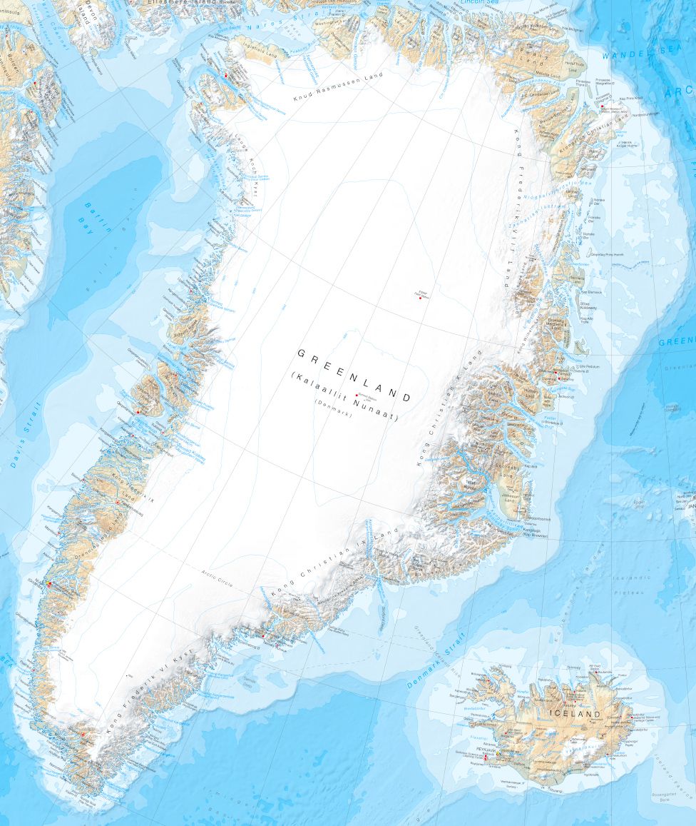
Record-low ozone levels currently stretch across much of the central Arctic, covering an area about three times the size of Greenland (see ‘Arctic opening’). The hole doesn’t threaten people’s health, and will probably break apart in the coming weeks. But it is an extraordinary atmospheric phenomenon that will go down in the record books.

“From my point of view, this is the first time you can speak about a real ozone hole in the Arctic,” says Martin Dameris, an atmospheric scientist at the German Aerospace Center in Oberpfaffenhofen.

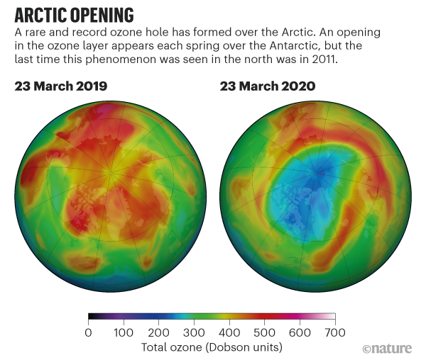
Source: NASA Ozone Watch

The hole’s formation

Ozone normally forms a protective blanket in the stratosphere, about 10 to 50 kilometres above the ground, where it shields life from solar ultraviolet radiation. But each year in the Antarctic winter, frigid temperatures allow high-altitude clouds to coalesce above the South Pole. Chemicals, including chlorine and bromine, which come from refrigerants and other industrial sources, trigger reactions on the surfaces of those clouds that chew away at the ozone layer.

The Antarctic ozone hole forms every year because winter temperatures in the area routinely plummet, allowing the high-altitude clouds to form. These conditions are much rarer in the Arctic, which has more variable temperatures and isn’t usually primed for ozone depletion, says Jens-Uwe Grooß, an atmospheric scientist at the Juelich Research Centre in Germany.

But this year, powerful westerly winds flowed around the North Pole and trapped cold air within a ‘polar vortex’. There was more cold air above the Arctic than in any winter recorded since 1979, says Markus Rex, an atmospheric scientist at the Alfred Wegener Institute in Potsdam, Germany. In the chilly temperatures, the high-altitude clouds formed, and the ozone-destroying reactions began.

Researchers measure ozone levels by releasing weather balloons from observing stations around the Arctic (including the Polarstern icebreaker, which is frozen in sea ice for a year-long expedition). By late March, these balloons measured a 90% drop in ozone at an altitude of 18 kilometres, which is right in the heart of the ozone layer. Where the balloons would normally measure around 3.5 parts per million of ozone, they recorded only around 0.3 parts per million, says Rex. “That beats any ozone loss we have seen in the past,” he notes.

The Arctic experienced ozone depletion in 1997 and in 20111, but this year’s loss looks on track to surpass those. “We have at least as much loss as in 2011, and there are some indications that it might be more than 2011,” says Gloria Manney, an atmospheric scientist at NorthWest Research Associates in Socorro, New Mexico. She works with a NASA satellite instrument that measures chlorine in the atmosphere, and says there is still quite a bit of chlorine available to deplete ozone in the coming days.

Is it dangerous?

Things would have been much worse this year if nations had not come together in 1987 to pass the Montreal Protocol, the international treaty that phases out the use of ozone-depleting chemicals, says Paul Newman, an atmospheric scientist at NASA’s Goddard Space Flight Center in Greenbelt, Maryland. The Antarctic ozone hole is now on its way to recovery — last year’s hole was the smallest on record — but it will take decades for the chemicals to completely disappear from the atmosphere.

The Arctic ozone hole isn’t a health threat because the Sun is just starting to rise above the horizon in high latitudes, says Rex. In the coming weeks, there is a small chance the hole might drift to lower latitudes over more populated areas — in which case people might need to apply sunscreen to avoid sunburn. “It wouldn’t be difficult to deal with,” Rex says.

The next few weeks are crucial. With the Sun slowly getting higher, atmospheric temperatures in the region of the ozone hole have already started to increase, says Antje Inness, an atmospheric scientist with the European Centre for Medium-Range Weather Forecasts in Reading, UK. Ozone could soon start to recover as the polar vortex breaks apart in the coming weeks.

“Right now, we’re just eagerly watching what happens,” says Ross Salawitch, an atmospheric scientist at the University of Maryland in College Park. “The game is not totally over.”

NASA Flights Detect Millions of Arctic Methane Hotspots

Thermokarst lake in Alaska
The image shows a thermokarst lake in Alaska. Thermokarst lakes form in the Arctic when permafrost thaws. Credit: NASA/JPL-Caltech
› Larger view

Knowing where emissions are happening and what’s causing them brings us a step closer to being able to forecast the region’s impact on global climate.


The Arctic is one of the fastest warming places on the planet. As temperatures rise, the perpetually frozen layer of soil, called permafrost, begins to thaw, releasing methane and other greenhouse gases into the atmosphere. These methane emissions can accelerate future warming – but to understand to what extent, we need to know how much methane may be emitted, when and what environmental factors may influence its release.

That’s a tricky feat. The Arctic spans thousands of miles, many of them inaccessible to humans. This inaccessibility has limited most ground-based observations to places with existing infrastructure – a mere fraction of the vast and varied Arctic terrain. Moreover, satellite observations are not detailed enough for scientists to identify key patterns and smaller-scale environmental influences on methane concentrations.

In a new study, scientists with NASA’s Arctic Boreal Vulnerability Experiment (ABoVE), found a way to bridge that gap. In 2017, they used planes equipped with the Airborne Visible Infrared Imaging Spectrometer – Next Generation (AVIRIS – NG), a highly specialized instrument, to fly over some 20,000 square miles (30,000 square kilometers) of the Arctic landscape in the hope of detecting methane hotspots. The instrument did not disappoint.

“We consider hotspots to be areas showing an excess of 3,000 parts per million of methane between the airborne sensor and the ground,” said lead author Clayton Elder of NASA’s Jet Propulsion Laboratory in Pasadena, California. “And we detected 2 million of these hotspots over the land that we covered.”

The paper, titled “Airborne Mapping Reveals Emergent Power Law of Arctic Methane Emissions,” was published Feb. 10 in Geophysical Research Letters.

Within the dataset, the team also discovered a pattern: On average, the methane hotspots were mostly concentrated within about 44 yards (40 meters) of standing bodies of water, like lakes and streams. After the 44-yard mark, the presence of hotspots gradually became sparser, and at about 330 yards (300 meters) from the water source, they dropped off almost completely.

The scientists working on this study don’t have a complete answer as to why 44 yards is the “magic number” for the whole survey region yet, but additional studies they’ve conducted on the ground provide some insight.

“After two years of ground field studies that began in 2018 at an Alaskan lake site with a methane hotspot, we found abrupt thawing of the permafrost right underneath the hotspot,” said Elder. “It’s that additional contribution of permafrost carbon – carbon that’s been frozen for thousands of years – that’s essentially contributing food for the microbes to chew up and turn into methane as the permafrost continues to thaw.”

Scientists are just scratching the surface of what is possible with the new data, but their first observations are valuable. Being able to identify the likely causes of the distribution of methane hotspots, for example, will help them to more accurately calculate this greenhouse gas’s emissions across areas where we don’t have observations. This new knowledge will improve how Arctic land models represent methane dynamics and therefore our ability to forecast the region’s impact on global climate and global climate change impacts on the Arctic.

Elder says the study is also a technological breakthrough.

“AVIRIS-NG has been used in previous methane surveys, but those surveys focused on human-caused emissions in populated areas and areas with major infrastructure known to produce emissions,” he said. “Our study marks the first time the instrument has been used to find hotspots where the locations of possible permafrost-related emissions are far less understood.”

More information on ABoVE can be found here:

https://above.nasa.gov/

U.S. agency agrees to designate habitat for threatened ice seals

Ringed and bearded seals live off Alaska’s northwest coast, both are listed as threatened

An adult ringed seal in Kotzebue, Alaska. Both ringed seals and bearded seals are listed as threatened in the U.S. (Mike Cameron/NOAA/Associated Press)
0
comments

A U.S. federal agency will decide by September how much ocean and coast will be designated as critical habitat for two ice seal species found in Alaska.

The Center for Biological Diversity announced Monday it had reached an agreement with the Commerce Department for the Trump administration to issue a critical habitat rule for ringed and bearded seals.

Ringed and bearded seals live off Alaska’s northwest coast. Both are listed as threatened.

Designation of critical habitat for threatened species is required by the Endangered Species Act a year after a listing. The Center for Biological Diversity sued in June because no critical habitat has been designated.

Federal agencies that authorize activities such as oil drilling within critical habitat must consult with wildlife managers to determine if threatened species will be affected.

Walrus sinks Russian Navy boat in the Arctic Ocean

The landing craft had been dispatched from the Russian rescue tug 'Altai', which is on the Northern Fleet's mission in the Arctic Ocean.

London & Moscow (CNN)walrus attacked and sunk a Russian Navy landing boat in the Arctic Ocean last week, with no one hurt in the incident.

According to the Russian Ministry of Defense, the female animal was protecting its calves when it targeted the craft carrying researchers to the shore of Cape Geller in the Arctic.
Those on board were members of a joint expedition by the Northern Fleet — Russia’s naval fleet in the Arctic — and the Russian Geographical Society (RGO).
The ministry said: “Serious troubles were avoided thanks to the clear and well-coordinated actions of the Northern Fleet servicemen, who were able to take the boat away from the animals without harming them.”
The RGO explained in a statement that the boat had “sunk” but confirmed that everyone had reached shore safely.
The organization added: “Recently, we wrote about the risks that accompany expedition members. Wild animals, storms, low temperatures.
“The incident is another confirmation that no one is expecting humans in the Arctic.”
The joint mission is working around the Franz Josef Land archipelago to investigate the flora and fauna of the region, as well as making glaciological observations.
It is also mapping historical expeditions such as those of Austro-Hungarian military officer Julius von Payer in 1874, and American explorer Walter Wellman in 1898.

Scientists will face polar bears, isolation and darkness on Arctic mission to study climate change

Bremerhaven, Germany — Three hundred scientists have been training in sub-zero temperatures in preparation for the trip of a lifetime. They will spend months trapped in sea ice, as part of a year long Arctic expedition, called MOSAiC, studying the effects of climate change. The expedition sets off from Norway on September 20.

“We are looking at creating a whole picture of what the Arctic is going to do in the coming years,” said Alison Fong, who heads up MOSAiC’s ecosystems research team.

Polar bears are a major concern, and she might have to swap her microscope for a rifle scope.

“All of our scientists are trained in polar bear safety, which includes carrying a rifle for protection. When we work in remote sites on the ice, we will take small electrical fences with us and personnel carrying rifles and flare guns and other types of safety equipment,” Fong said.

Home base is a German icebreaker, the Polarstern. It will be fitted with scientific equipment, turning it into a floating laboratory.

patta-climate-arctic-ice-mission-frame-1765.jpg
The Polarstern will serve as home base for scientists studying climate change in the Arctic.  CBS NEWS

What happens in the Arctic doesn’t stay in the Arctic. It’s generally considered an early warning system for the impact of climate change, and scientists are hoping the expedition on this ship will raise their understanding of it to a whole new level.

Getting a taste of what lies ahead, the scientists practiced using a remotely controlled device which measures light through the ice, and drilling through the core to assess ice thickness.

The Arctic is warming faster than anywhere else on Earth but scientists have never been able to conduct research in the remote northern parts of it during winter. Now they will attempt an unprecedented scientific mission. The crew will sail close to the North Pole, cut the engine and wait for water to freeze around the vessel. They will then simply drift with the ice flow.

“You have seen that in the U.S. at the beginning of this year when the snowstorms and blizzards went down to Florida — that is all driven by climate change in the Arctic, and we need to understand that to understand how our extreme weather in the future will look like,” said Markus Rex, the expedition leader.

patta-climate-arctic-ice-mission-frame-2660.jpg
Scientists will brave the Arctic in order to study the effects of climate change.  CBS NEWS

Mental fortitude during this mission is a formidable challenge. The scientists are bracing themselves for long periods of total isolation and complete darkness. In the winter months they will never see daylight. But freezing yourself in ice is worth it, they believe, if it helps save humanity from the extreme consequences of a warming world.


CBS News, along with more than 250 news outlets worldwide, is participating in the Covering Climate Now project, a joint initiative founded by the Columbia Journalism Review and The Nation magazine. CBS News, the only broadcast network, is devoting this week to covering climate change, leading up to the United Nations Climate Action Summit  in New York on September 23.

‘Unprecedented’ wildfires ravage the Arctic

Wildfire smoke is spreading from Alaska across parts of Canada.

Story highlights

  • The wildfires come as the planet is on track to experience the hottest July on record
  • Wildfires contribute to global warming by releasing carbon dioxide into the atmosphere

(CNN)More than 100 intense wildfires have ravaged the Arctic since June, with scientists describing the blazes as “unprecedented.”

New satellite images show huge clouds of smoke billowing across uninhabited land in Greenland, Siberia and parts of Alaska.
The wildfires come after the planet experienced the hottest June on record and is on track to experience the hottest July on record, as heatwaves sweep across Europe and the United States.
Since the start of June, Copernicus Atmosphere Monitoring Service (CAMS), which provides data about atmospheric composition and emissions, has tracked more than 100 intense wildfires in the Arctic Circle.
Pierre Markuse, a satellite photography expert, said the region has experienced fires in the past, but never this many.
Satellite images show smoke billowing across Greenland and Alaska as wildfires ravage the region.

Temperatures in the Arctic are rising at a faster rate than the global average, providing the right conditions for wildfires to spread, according to Mark Parrington, a senior scientist at CAMS.
“The number and intensity of wildfires in the Arctic Circle is unusual and unprecedented,” Parrington told CNN.
“They are concerning as they are occurring in a very remote part of the world, and in an environment that many people would consider to be pristine,” he said.
See how Europe is dealing with an extreme heatwave

Play Video

See how Europe is dealing with an extreme heatwave 01:34
The average June temperature in Siberia, where the fires are raging, was almost 10 degrees higher than the long-term average between 1981–2010, Dr Claudia Volosciuk, a scientist with the World Meteorological Organization (WMO) told CNN.
Parrington said there seemed to be more wildfires due to local heatwaves in Siberia, Canada and Alaska.
The fires themselves contribute to the climate crisis by releasing carbon dioxide into the atmosphere.
They emitted an estimated 100 megatons of carbon dioxide (CO2) into the atmosphere between 1 June and 21 July, almost the equivalent of Belgium’s carbon output in 2017, according to CAMS.
Volosciuk said wildfires are also exacerbating global warming by releasing pollutants into the atmosphere.
“When particles of smoke land on snow and ice, [they] cause the ice to absorb sunlight that it would otherwise reflect, and thereby accelerate the warming in the Arctic,” she said.

Small Temperature Bumps Can Cause Big Arctic Methane Burps

Warming can encourage the growth of microbes in permafrost that produce more greenhouse gases

Small Temperature Bumps Can Cause Big Arctic Methane Burps
Thawing permafrost on the tundra of Wrangel Island. Credit: Jenny E. Ross Getty Images

As temperatures rise in the rapidly warming Arctic, scientists are growing more and more concerned about the region’s permafrost—the carbon-rich, frozen soil that covers much of the landscape. As permafrost warms up and begins to thaw out, microbes in the soil may release large quantities of both climate-warming carbon dioxide and methane into the atmosphere, potentially worsening the effects of climate change.

Researchers are carefully monitoring the natural emissions from permafrost in the Arctic. And in recent years, they’ve also begun designing their own experiments aimed at investigating the way the frozen soil might react to future climate change.

They’re finding that even a little bit of warming may cause permafrost to release significantly higher levels of greenhouse gases into the air.

The new study relied on experiments from a special research site in Alaska, where scientists have designed a way to manipulate the natural landscape to investigate the effects of rising temperatures. They’ve built special fences that allow snow to pile up deeper on the ground, forming a kind of insulation and causing the permafrost below the surface to warm up. Permafrost at the experimental sites was around a degree Celsius warmer than nearby sites that hadn’t been insulated.

The research site—known as the Carbon in Permafrost Experimental Heating Project—provides a unique opportunity to simulate the effects of future climate change. In a laboratory setting, it might be more difficult to exactly reconstruct the natural landscape, making scientists less sure of their results.

For the new study, the researchers conducted special forms of genetic sequencing to determine how microbe communities changed in the warmer plots. The shifts were apparent after less than five years of elevated temperatures.

In shallower layers of the soil, they found an increase in microbes that produce more carbon dioxide. And in deeper layers, they found an increase in microbes that produce larger amounts of methane, an even more potent greenhouse gas. At the same time, methane emissions from the experimental sites also increased.

The study provides experimental support for scientists’ ongoing fears about thawing permafrost. Throughout the Arctic, researchers are finding that large swaths of frozen soil are steadily heating up, sometimes faster than scientists had previously predicted.

The research also underscores a growing scientific interest in the links between climate change and the world’s tiniest organisms.

In addition to permafrost, they pointed to changes in microbe communities that affect the ocean’s carbon uptake and the marine food web, lead to algae blooms, alter the growth of vegetation, influence agricultural production, and contribute to the spread of infectious diseases.

Reprinted from Climatewire with permission from E&E News. E&E provides daily coverage of essential energy and environmental news at www.eenews.net.

Scientists shocked by Arctic permafrost thawing 70 years sooner than predicted

  • Ice blocks frozen solid for thousands of years destabilized
  • ‘The climate is now warmer than at any time in last 5,000 years’
A cemetery sitting on melting permafrost tundra at the village of Quinhagak on the Yukon Delta in Alaska.The scientists’ findings offer a further sign of a growing climate emergency.
 A cemetery sitting on melting permafrost tundra at the village of Quinhagak on the Yukon delta in Alaska. The scientists’ findings offer a further sign of a climate emergency. Photograph: Mark Ralston/AFP/Getty Images

Permafrost at outposts in the Canadian Arctic is thawing 70 years earlier than predicted, an expedition has discovered, in the latest sign that the global climate crisis is accelerating even faster than scientists had feared.

A team from the University of Alaska Fairbanks said they were astounded by how quickly a succession of unusually hot summers had destabilised the upper layers of giant subterranean ice blocks that had been frozen solid for millennia.

“What we saw was amazing,” Vladimir Romanovsky, a professor of geophysics at the university, told Reuters. “It’s an indication that the climate is now warmer than at any time in the last 5,000 or more years.“

With governments meeting in Bonn this week to try to ratchet up ambitions in United Nations climate negotiations, the team’s findings, published on 10 June in Geophysical Research Letters, offered a further sign of a growing climate emergency.

The paper was based on data Romanovsky and his colleagues had been analysing since their last expedition to the area in 2016. The team used a modified propeller plane to visit exceptionally remote sites, including an abandoned cold war-era radar base more than 300km from the nearest human settlement.

Diving through a lucky break in the clouds, Romanovsky and his colleagues said they were confronted with a landscape that was unrecognisable from the pristine Arctic terrain they had encountered during initial visits a decade or so earlier.

The vista had dissolved into an undulating sea of hummocks – waist-high depressions and ponds known as thermokarst. Vegetation, once sparse, had begun to flourish in the shelter provided from the constant wind.

Torn between professional excitement and foreboding, Romanovsky said the scene had reminded him of the aftermath of a bombardment.

“It’s a canary in the coalmine,” said Louise Farquharson, a postdoctoral researcher and co-author of the study. “It’s very likely that this phenomenon is affecting a much more extensive region and that’s what we’re going to look at next.“

Scientists are concerned about the stability of permafrost because of the risk that rapid thawing could release vast quantities of heat-trapping gases, unleashing a feedback loop that would in turn fuel even faster temperature rises.

With scientists warning that sharply higher temperatures would devastate the global south and threaten the viability of industrial civilisation in the northern hemisphere, campaigners said the new paper reinforced the imperative to cut emissions.

“Thawing permafrost is one of the tipping points for climate breakdown and it’s happening before our very eyes,” said Jennifer Morgan, executive director of Greenpeace International. “This premature thawing is another clear signal that we must decarbonise our economies, and immediately.”

Greenland map captures changing Arctic in fine detail

GreenlandImage copyrightBAS
Image captionThe printed sheet map is 1:4,000,000 scale (1cm = 40km; 1 inch = 63 miles)
Presentational white space

The Arctic is changing rapidly. It’s warming twice as fast as the rest of the planet.

The seasonal sea-ice is in long-term decline and the ice sheet that sits atop Greenland is losing mass at a rate of about 280 billion tonnes a year.

So, if you choose to make a map of the region, you start from the recognition that what you’re producing can only be a snapshot that will need to be updated in the relatively near future.

Laura Gerrish, a geographical information systems and mapping specialist at the British Antarctic Survey (BAS), knows this. Polar science and polar cartography are all about tracing change.

Laura has just finished making a exquisite new printed sheet map (1:4,000,000) of Greenland.

The detail is a delight – from the winding path of all the fjords and inlets, to the precise positioning of current ice margins, and the use of all those tongue-twisting Greenlandic names.

Nuuk city old harbourImage copyrightGETTY IMAGES
Image captionThe Arctic is one of the fastest warming places on Earth

“The map is a little unusual because the area has not been shown on one sheet like this before,” explains Laura.

ADVERTISEMENT

“We have good maps, obviously, of Europe, of Iceland, of Svalbard – but there is nothing that puts them all together on one sheet and shows their relationship like this.

“The map is aimed at scientists, clearly; BAS is a scientific organisation. But we hope tourists on cruise ships and any visitors to Greenland will find it useful, as well as schools or anyone with an interest in the Arctic.”

Media captionLaura Gerrish and Henry Burgess: “It’s aimed at scientists, tourists, visitors and schools”

Greenland And The European Arctic, to give the map its full title, has taken nearly two years to put together.

Laura has had to call on more than a dozen data-sets to get the shape of Greenland exactly right. These have been checked against the latest satellite imagery to ensure physical features are where they’re supposed to be.

One or two features, such as islands in the Qimusseriarsuaq (Melville Bay) region, are new because they’ve only recently been revealed by contracting ice fronts.

Full mapImage copyrightBAS
Image captionThe map renders Greenland in relation to northern Europe

Care has been taken in particular to plot the present extents of all the glaciers, including the big ice streams that sometimes hit the science headlines, such as Jakobshavn, Petermann, Zachariae Isstrom, and Helheim.

These glaciers have demonstrated some remarkable retreat behaviour. Although just to prove what a thankless task this business can be, they’ve also shown recently that they can slow and lengthen as well (the net area of 47 regularly surveyed glaciers essentially stood still last year).

You might wonder what the British Antarctic Survey is doing making maps of the polar north. Henry Burgess, the head of the NERC Arctic Office which is hosted at the survey’s HQ in Cambridge, has a simple answer.

“BAS is the national capability and logistics provider for the polar regions,” he told me. “It provides the ships and the planes and the expertise, and the BAS mapping department therefore has a responsibility in both the north and the south.”

Henry is especially pleased with the flip side of the sheet map. This has a series of panels that attempt to put the cartography in a wider context.

Different organisations from the UK Met Office to WWF have provided small summaries on various issues that range from the effects that a warming arctic are having on frozen ground and on weather at mid latitudes, to the challenges climate change presents to indigenous peoples and endemic wildlife.

Hopefully, the new fold-out sheet map of Greenland And The European Arctic should be good for at least a few years, but says Henry: “We’re seeing dramatic changes in Svalbard for example where we have our Arctic station; the glaciers are pulling back by 10s of metres per year. So, yes, mapping is a constant process.”

Jakobshavn GlacierImage copyrightSENTINEL HUB
Image captionJakobshavn Glacier spits out icebergs in Disko Bay on the west coast
Back sheetImage copyrightBAS
Image captionThe reverse of the sheet map puts changes in the Arctic in context

The Greenland and the European Arctic map is available for sale as either a flat wall map or a folded map at several outlets, including the Scott Polar Research Institute and Stanfordsmap store in London.

As Polar Ice Cap Recedes, The U.S. Navy Looks North

An F/A-18 Super Hornet gets ready to fly off the USS Theodore Roosevelt in the Gulf of Alaska.

Zachariah Hughes/Alaska Public Media

The U.S. Navy is looking north.

As climate change melts ice that has long blocked the region off from transit and industry, the military is figuring out how to expand its presence in the waters of the high north, primarily off the coast of Alaska.

Driving the push is that much of the commercial activity and development interest in the region is coming from nations that the Pentagon considers rivals, such as Russia and China.

The Navy’s presence in Alaska has waxed and waned over the years. The state has abundant Army and Air Force assets, with the Coast Guard spread throughout. The Navy runs submarine exercises beneath the sea ice off Alaska’s northern coast.

But until last year, no U.S. aircraft carrier had ventured above the Arctic Circle in almost three decades. The USS Harry S. Truman took part in naval exercises in the Norwegian Sea last October, the first such vessel to sail that far north since 1991.

And for the first time in a decade, this May, an aircraft carrier strike group — led by the USS Theodore Roosevelt — sailed to Alaska as part of Northern Edge, a biennial large-scale military exercise that brings together personnel from all the military branches — airmen, Marines, soldiers, seamen and Coast Guardsman. The Navy always participates, but this year, it was out in force.

Lt. Cmdr. Alex Diaz oversees traffic on the USS Theodore Roosevelt flight deck.

Zachariah Hughes/Alaska Public Media

Rear Adm. Daniel Dwyer commands the nine ships in the Roosevelt strike group. Speaking on an observation deck several stories above the flight deck, he said climate change is adding a new urgency to training like this one as marine activity increases in Arctic waters.

“You see the shrinking of the polar ice cap, opening of sea lanes, more traffic through those areas,” Dwyer said. “It’s the Navy’s responsibility to protect America through those approaches.”

The Defense Department views the threat of military conflict in the Arctic as low, but it is alarmed by increasing activity in the region from Russia and China. A 2018 reportby the Government Accountability Office on the Navy’s role in the Arctic notes that abundant natural resources like gas, minerals and fish stocks are becoming more accessible as the polar ice cap melts, bringing “competing sovereignty claims.”

Defending U.S. interests in the Arctic

As the Roosevelt cruised through the Gulf of Alaska, F/A-18 Super Hornets took off and landed at a brisk clip. Each takeoff is a full-body experience for those on deck, shaking everything from one’s shoes to teeth. Planes are launched by a steam catapult system powered by the ship’s nuclear reactors.

Some of the jets flew more than 100 miles toward mainland Alaska and continued on past mountain ranges to sync up with Air Force and Marine Corps counterparts operating in the airspace around Eielson Air Force Base near Fairbanks. Then they returned to the Roosevelt. The whole trip lasts about four hours.

For the first time in a decade, an aircraft carrier strike group — led by the USS Theodore Roosevelt — sailed to Alaska as part of Northern Edge, a biennial large-scale military exercise.

Zachariah Hughes/Alaska Public Media

To land, the Super Hornets suddenly dropped out of the sky dangling a hook that snagged at wires bringing them from full speed to full stop in 183 feet. It looked less like a car braking and more like a roller coaster slamming still to give riders one last jolt.

“We are catching anywhere from six to 25 aircraft on this recovery,” crackled a voice over a loudspeaker on the deck. “I’m not sure yet [how many]. If they show up on the ball, we’re gonna catch ’em.”

The deck was coordinated chaos, with crew members and aircraft rotating through intricate maneuvers like a baroque ballet, billows of steam from the launch equipment periodically billowing past.

The deck crews are referred to as “skittles” because they wear uniforms that are color-coordinated to match their jobs. Much like the candy, most of the rainbow is represented. Greens take care of takeoffs and landings. Reds handle ordnance. Purples deal with fuel and are referred to as “grapes.”

The Navy says that given what is expected of it in the region, crews are trained and equipped to carry out their missions as well as any other nation’s navy.

“Regardless of the conditions: day, night, good weather, bad weather, flat seas, heavy seas, it’s the same procedure every time,” Dwyer said of the jets taking off below just as a helicopter set down on the flight deck.

A shifting focus to the “high north”

Speaking at this year’s Coast Guard Academy commencement, national security adviser John Bolton said the military will play a part “reasserting” American influence over the Arctic.

“We want the high north to be a region of low tension, where no country seeks to coerce others through military buildup or economic exploitation,” Bolton told graduates.

The Trump administration is expected to unveil a new Arctic strategy sometime this month.

Forecasters anticipate diminishing ice will reliably open up northern sea lanes, thus cutting down the time and cost moving freight from Asia to Europe but causing a rise in vessel traffic.

The military is candid that the warming climate is opening up transit routes that sea ice has long locked in. Right now, though, the U.S. naval presence is minimal.

F/A-18 Super Hornet is launched by a steam-powered catapult off the USS Theodore Roosevelt during naval exercises in the Gulf of Alaska.

Zachariah Hughes/Alaska Public Media

“If you’re gonna be a neighbor, you have to be in the neighborhood,” said Vice Adm. John Alexander, commander of the Navy’s 3rd Fleet, which is responsible for the Northern Pacific, including the Bering Sea and Alaskan Arctic.

“We’re going to have to ensure that there’s free and open transit of those waters,” Alexander said.

But the Navy faces major impediments to expanding its presence in a maritime environment as harsh as the Arctic. According to the GAO report, most of the Navy’s surface ships aren’t “designed to operate in icy water.”

The authors note that Navy officials have stated that “contractor construction yards currently lack expertise in the design for construction of winterized, ice-capable surface combatant and amphibious warfare ships.”

After years of study, the Defense Department has yet to pick a location and design for a strategic port in the vicinity of the Arctic that can permanently accommodate a strong Navy presence.

And even if the military can operate in the Arctic, it still has to get there. For now, the region’s waters are solidly frozen over for much of the year. According to the Coast Guard, Russia has more than 40 icebreakers, including three new gargantuan nuclear-powered vessels designed to ply sea lanes along the northern sea route. The U.S. military, by contrast, has just two working icebreakers.

This story comes from American Homefront, a military and veterans reporting project from NPR and member stations.